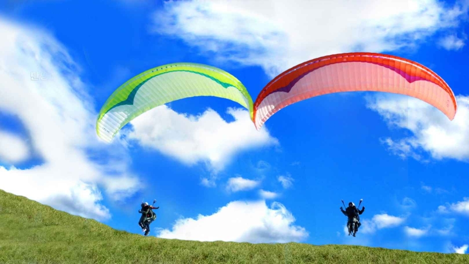
Eorayeon Valley -Gangwon Paleozoic Geopark (어라연-강원고생대 국가지질공원) - Area information - Korea travel information

Eorayeon Valley -Gangwon Paleozoic Geopark (어라연-강원고생대 국가지질공원)

Eorayeon Valley -Gangwon Paleozoic Geopark (어라연-강원고생대 국가지질공원)

11.5Km    8440     2022-12-29

259 , Eorayeon-gil, Yeongwol-gun, Gangwon-do
+82-33-372-1705

A beautiful and mysterious valley located 12 km up the Donggang River, Eorayeon Valley is renowned for its clean waters and for the many fish that inhabit it. The valley has beautiful rock formations and a dense pine forest that were designated as the National Scenic Spot in December 2004. It is one of Korea's most popular sites for rafting, followed by Naerincheon Creek and Cheorwon's Hantangang River. The trail to Eorayeon through Jatbong Peak is also quite popular (approx. 3 hours).

Guinsa Temple (Danyang) (구인사(단양))

Guinsa Temple (Danyang) (구인사(단양))

11.9Km    47661     2024-03-15

73 Guinsa-gil, Yeongchun-myeon, Danyang-gun, Chungcheongbuk-do
+82-43-423-7100

Danyang Bobaljae Pass (단양 보발재)

Danyang Bobaljae Pass (단양 보발재)

11.9Km    0     2024-02-26

San 26-7, Baekja-ri, Yeongchun-myeon, Danyang-gun, Chungcheongbuk-do

Bobaljae Pass is located 540 m above sea level on the northern side of Sobaeksan Mountain. It is also known as Godeuneomijae Pass. The S-shaped curve is known for wildflowers in spring and fall foliage in autumn, so one can either take a leisurely drive along the road or park one’s car at the observatory and get some pictures. Guinsa Temple and Ondal Tourist Area nearby are also good to visit.

Seondol Cliff [National Geopark] (선돌 (강원고생대 국가지질공원))

Seondol Cliff [National Geopark] (선돌 (강원고생대 국가지질공원))

12.3Km    56274     2022-12-28

373-1, Bangjeol-ri, Yeongwol-gun, Gangwon-do
+82-1577-0545

Seondol Cliff features a large split rock standing over the curving river below. The scene created by these two natural elements appears other-worldly. A rocky outcrop appears to have been cut away from the main cliff with a giant knife. Geologically, it was formed by corrosion of the limestone bedrock.

Baengnyongdonggul Cave-Gangwon Paleozoic Geopark (백룡동굴-강원고생대 국가지질공원)

16.8Km    13092     2020-06-10

63, Munhui-gil, Pyeongchang-gun, Gangwon-do
+82-33-560-2379

Baengnyongdonggul Cave is a 1.8㎞-long, natural limestone cave located in Pyeongchang-gun, Gangwon-do. The cave entrance is located 10-15㎞ above sea level, and is surrounded by rocks. In 1976, local residents expanded a small lane in the middle of the main cave corridor to allow for easier exploration. Since then, the cave has continued to be explored and researched with great value for geologists. The cave was designated Natural Monument No. 260 in 1979.

Sansogui Chingu (농가맛집 산속의 친구)

Sansogui Chingu (농가맛집 산속의 친구)

17.8Km    2334     2024-01-09

132-54 Deokjeon-gil, Buk-myeon, Yeongwol-gun, Gangwon-do

Sansogui Chingu, which means "a friend in the mountains," is a recognized restaurant in Yeongwol that has earned the title "Nongga Matjip," which means Delicious Farmhouse Restaurant. It has the cozy ambience of a typical countryside tile-roofed farmhouse. The restaurant makes their own soybean and red pepper paste, which are stored in the numerous crocks seen by the restaurant building. The restaurant's signature menu is Gangwon Namul Bap (wild vegetable rice set menu). The appetizing wild vegetables such as fisher’s ragwort, cow parsnip, and thistle are seasoned with housemade soy sauce, pastes, and enzymes, giving a deep and rich taste that cannot be achieved with additives or store bought seasonings. Visitors can also purchase soybean paste, soy sauce, red chili paste, and rich soybean paste made in the traditional way.

Sobaeksan National Park (Northern Section) (소백산국립공원(북부))

Sobaeksan National Park (Northern Section) (소백산국립공원(북부))

17.9Km    28195     2021-06-15

494, Namhangang-ro, Danyang-gun, Chungcheongbuk-do
+82-43-423-0708

Sobaeksan Mountain is renowned for its natural splendor and mystery, standing tall in the middle of the Korean peninsula, and offering several magnificent peaks, such as Hyeongjebong, Sinseonbong, Gungmangbong, Birobong, and Yeonhwabong. Its captivating seasonal beauty attracts visitors year round. The moutain's recreational forest was designated as the third national park in Chungcheongbuk-do in 1987, following Songnisan Mountain and Woraksan Mountain in 1970 and 1984 respectively. The open grass field on Birobong Peak (1,439 meters) resembles the Swiss Alps. On Yeonhwabong Peak (1,349 meters) is Sobaeksan Optical Astromony Observatory (SOAO), which laid the foundation for Korea's astronomy.

Pyeongchang Eoreumchi Village (평창 어름치마을)

Pyeongchang Eoreumchi Village (평창 어름치마을)

17.9Km    12034     2024-02-16

42-5 Maha-gil, Mitan-myeon, Pyeongchang-gun, Gangwon-do

Pyeongchang Eoreumchi Village is dedicated to preserving the habitat of the Eoreumchi (Cyprinid Fish), a natural monument that thrives in pristine environments. The village offers immersive rural experiences and ecotourism activities. Visitors have the opportunity to engage in water sports like rafting and kayaking on the Donggang River, as well as mountain climbing on Baegunsan Mountain. Other activities include trekking through Chiljokryeong and exploring the Baengnyongdonggul Cave. Reservations for these experiences can be made through their website.

Korean Peninsula Terrain [National Geopark] (한반도지형 (강원고생대 국가지질공원))

Korean Peninsula Terrain [National Geopark] (한반도지형 (강원고생대 국가지질공원))

19.4Km    12760     2024-04-08

555 Hanbando-ro, Hanbando-myeon, Yeongwol-gun, Gangwon-do

Korean Peninsula Terrain was formed by soil transported from upstream to the curvature of the confluence of two rivers. It is often referred to as Mini Korean Peninsula because it resembles the shape of the Korean Peninsula. It is said to have this appearance due to the erosion of the incised stream flowing around the terrain. It takes a 15-minute walk along the pine forest trail for about 800 meters from the parking lot to reach there. The well-maintained trail with many wildflowers and plants creates a welcoming atmosphere. Upon arriving at the observation point, visitors will be amazed by the beautiful curved river and the topography taking the same shape as the Korean Peninsula. Designated as the Gangwon Paleozoic National Geopar, this area has excellent geographical value because it shows the characteristics of the incised mender river as well.

Hanbando Raft Village (한반도 뗏목마을)

Hanbando Raft Village (한반도 뗏목마을)

19.6Km    33770     2024-01-09

70 Seonam-gil, Hanbando-myeon, Yeongwol-gun, Gangwon-do

The Hanbando Raft Village is a raft experience center in Seonam Village, Ongjeong-ri, famous for its topography in the shape of the Korean Peninsula. It takes about 30 minutes to go back and forth on a raft from the east coast of the Mini Korean Peninsula to the west coast. While riding the raft, the boatman tells the story of the topography of the Mini Korean Peninsula and the fish living here. It is available from spring to autumn. In addition, various raft experiences are under operation, such as the Seogang Underwater Surveyor, a remodeled rafting boat that allows you to clearly view the underwater scenery.