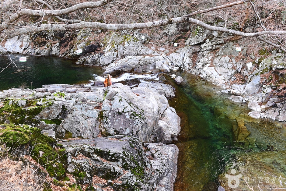
Jirisan Chilseongyegok Valley (칠선계곡(지리산))
13.7Km 2022-07-29
Chuseong-ri, Hamnyang-gun, Gyeongsangnam-do
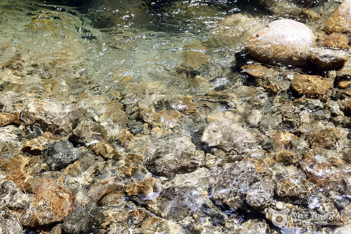
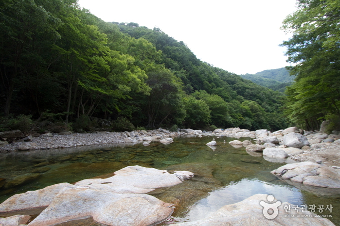
Chilseongyegok Valley is the most beautiful valley in Jirisan Mountain, and is one of the top three valleys in the nation, along with Cheonbuldonggyegok Valley in Seoraksan Mountain and Tamnagyegok Valley in Hallasan Mountain. The 16-kilometer valley stretching from Uitan of Macheon-myeon to Cheonwangbong Peak is characterized by very tough topography but beautiful scenery and is the only remaining primeval forest of Jirisan Mountain. It is also dotted with seven waterfalls and 33 ponds. The hike becomes more difficult as the trail enters the valley. Because the valley has taken many lives, some people call it "The Valley of Death." For that reason, visitors must apply in advance and hike with a guide. The trail in Chilseon Valley is a 9.4-kilometer course from Chuseong Village in Macheon-myeon to Cheonwangbong Peak, which does not follow the natural valley, due to the valley's steep and dangerous features. Starting from Chuseong Village, the trail passes Yongso Pond, Jujiteo Site, Chuseongmang Rock, Seonnyeotang Pond, Ongnyeotang Pond, Biseondam, Chilseonpokpo Falls, Daeryukpokpo Falls, Samcheungpokpo Falls and Mapokpo Falls, all before reaching Cheonwangbong Peak.
Baemsagolgyegok Valley (뱀사골 계곡)
14.2Km 2024-04-07
Buun-gil, Namwon-si, Jeonbuk-do
Located in Namwon, Jeollabuk-do, Baemsagolgyegok is a 9-km grand valley, situated at the northern foot of Jirisan Mountain. Stretching from Banyabong Peak and Tokkibong Peak toward Sannae-myeon of Namwon-si, the valley is renowned for its beautiful autumn foliage.
Baemsagolgyegok Valley is popular as a summer vacation destination because there’s always an abundance of water and trees. In the fall, the hills become ablaze with autumn tints, small streams flow over rock beds, and small pools of clear water from under the rocks create a beautiful sight. Other notable places nearby include Seonindae, Seoksil, Yoryongdae, Tagyongso, Byeongso, Byeongpungso, Jeseungdae and Ganjangso.
Sancheong Daewonsa Temple (대원사(산청))
15.8Km 2021-08-13
453, Pyeongchonyupyeong-ro, Sancheong-gun, Gyeongsangnam-do
Located at the eastern foot of Jirisan Mountain, Daewonsa Temple was first built in 548 during the Silla dynasty, but it remained closed for over thousand years until it was renovated and made bigger with the name Daewon. Unfortunately, the entire premises were lost to a big fire during the night of January 12, 1914, and all the halls and pavilions, including Yosachae, totaling 184 rooms in 12 buildings, were rebuilt in 1917. However, they were damaged once again during the Korean War and were abandoned until the war ended where the temple was rejuvenated and made even bigger. Located nearby are Geoyeonjeong and Gunjajeong Halls that are believed to have been the studying venue of scholars.
* Daewonsa Valley
The two-kilometer-long valley that stretches from the parking lot at the entrance to Daewon Temple to the temple itself is surrounded by high hills and curious-looking rocks. The clean water that oozes out through craters between the rocks generates unusual scenery. Associated with Yongso Pond is the legend that a dragon lived in it for hundreds of years before it finally flew away. Somakgol Valley is known to be the place where the last king of Garak Kingdom came to feed his cows and horses.
Baemsagol Waun Village (뱀사골 와운마을)
16.7Km 2024-04-07
249 Waun-gil, Namwon-si, Jeonbuk-do
Baemsagol Waun Village is located deep in the heart of Jirisan Mountain, being almost impossible to find if one didn't know the pathway in the past. The village is located within a 14 kilometer-long valley with many strangely shaped rocks. The village is home to an old pine tree (Natural Monument) that is lovely referred to as "Grandmother Tree."
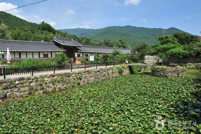
Gurye Unjoru Historic House (구례 운조루 고택)
16.9Km 2025-10-23
59 Unjoru-gil, Gurye-gun, Jeollanam-do
Unjoru Historic House was built in 1776 by Ryu I-Ju, a high government official of the Sam-su Department during the reign of King Yeong-jo. Of the house's original 99 kan (traditional building measurement), only 73 remain today. The name Unjoru means "a hidden house like a bird in the clouds," which was inspired from an old poem written by poet Tao Yuan Ming.

Seoamjeongsa Temple (서암정사(함양))
17.0Km 2024-02-21
27-79 Gwangjeom-gil, Macheon-myeon, Hamyang-gun, Gyeongsangnam-do
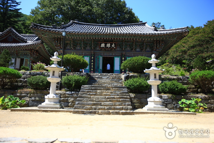
Seoamjeongsa Temple belongs to Byeoksongsa Temple, which is at the entrance of the Chilseongyegok Valley of Jirisan Mountain. Monk Woneung rebuilt Byeoksongsa Temple, which had been damaged during the Korean War in 1950. This hermitage features the Buddha statues Woneung carved into the natural bedrock, a grotto sanctuary with statues of the Pure Land, Daebanggwangmun Gate, and Sajagul Cave.
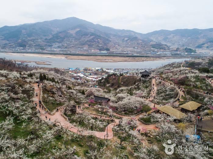
Gwangyang Maehwa Village (광양 매화마을)
17.8Km 2025-01-08
1563-1 Seomjingangmaehwa-ro, Gwangyang-si, Jeollanam-do
Following the Seomjingang River flowing down the outskirts of Jirisan Mountain is a village filled with plum trees. This village, Seomjin Village, is also known as the Maehwa (plum) Village for its abundant number of plum trees. Instead of crops and grains, plum trees are cultivated on farmlands, boasting white snow-like blossoms in March and bearing ripe plums in June. The annual Plum Blossom Festival takes place in the village every March when the plum blossoms are in full bloom.
Ssangsanjae (쌍산재)
18.3Km 2025-10-23
3-2 Jangsu-gil Masan-myeon, Gurye-gun, Jeollanam-do
It is a 300-year-old old house where you can feel the traditional beauty and atmosphere of a Hanok, and 15 large and small Hanoks are scattered on a site of 16,500㎡. The top and bottom are divided around a bamboo forest stretching toward the sky, and over 100 types of trees and plants are harmonized with the building like a picture. For an entrance fee, coffee or tea is provided, so you can take a seat wherever you like and have a cup of tea while looking around the inside. While enjoying the quiet atmosphere, let's fully look around various points such as the detached house, bamboo forest, Hoseojeong, and Gyeongamdang.
Dalgunggyegok Valley (달궁계곡)
18.3Km 2024-04-07
Jirisan-ro, Sannae-myeon, Namwon-si, Jeonbuk-do
Dalgunggyegok Valley is a valley located within the Jirisan National Park. It spans 6 kilometers from Dalgung Village to Simwon Village. Surrounded by dense primeval forests, it showcases the pristine beauty of an untouched valley where human hands have yet to reach. The combination of the valley and cliffs creates stunning scenery. Nearby Dalgung Village also preserves remnants of ancient Mahan palaces.
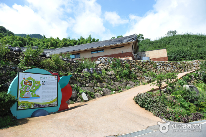
Cheong Maesil Farm (홍쌍리 청매실농원)
18.3Km 2024-02-01
55 Jimak 1-gil, Daap-myeon, Gwangyang-si, Jeollanam-do
Cheong Maesil Farm sprawls across an expansive area of over 165,000 m2 at the foothills of Baegunsan Mountain, which rises to an elevation of 1,217 meters. The farm has been lovingly tended to by the renowned Plum Blossom Doctor, Hong Ssang-ri, for decades, drawing visitors from all over the country. In March, Cheong Maesil Farm transforms into a breathtaking canvas of colors—with blue and red plums, the delicate lily trees and the vibrant cornelian cherries all blossoming in unison. For photo enthusiasts, the farm boasts a dedicated photo zone, while the Pavilion Observatory offers panoramic views that are a favorite among visitors. From this spot, one can marvel at the picturesque scenery of Gwangyang Maehwa Village, Seomjingang River, and Hadong Village on the river’s other side. Visitors in spring are recommended to attend the annual plum festival centered around Cheong Maesil Farm. Moreover, the nearby Gwangyang Plum Culture Center makes for an enriching stopover.
 English
 한국어
한국어 日本語
日本語 中文(简体)
 Deutsch
 Français
 Español
 Русский