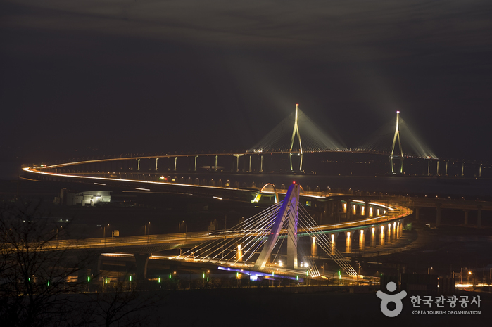
Incheon Bridge (인천대교)
2019-08-28
3, Incheondaegyo Expressway, Jung-gu, Incheon
+82-32-745-8000
Incheon Bridge is the longest bridge in Korea with the 21.39km long. It is ranked seventh in the world for its bridge length, sixth in the world ranking as a 18.38km long cable-stayed bridge, and fifth in the world ranking for its 800m gap between two main towers.
The bridge connects between Yeongjongdo Island, developing an international distribution complex as well as international airport, and Songdo Island, growing an international business city, within 20 minutes. Also, it grants easy to access to Gyeongin Expressway No. 2 and 3, and Seohaean Expressway by shortening more than 40 minutes to arrive at Incheon International Airport.
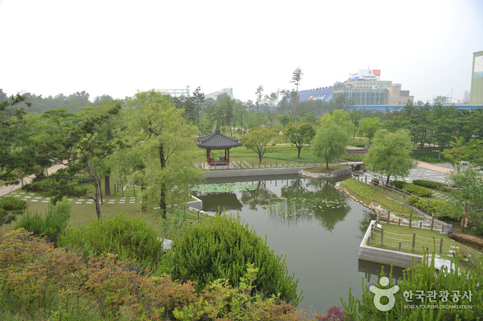
Wolmi Park (월미공원)
2026-06-30
131-22 Wolmi-ro, Jemulpo-gu, Incheon
Wolmi Park, once a military zone for 50 years following the Korean War (1950-1953), has been transformed into a park preserving its natural ecosystem. Centered around Wolmi Mountain, the park features traditional Korean gardens such as Palace Garden, Hermitage Garden, and Tradition Private House Garden. Visitors can enjoy views of Incheon Port and the sunset over the Seohae Sea from the nearby Wolmi Observatory. It is conveniently located near Wolmi Cultural Street.
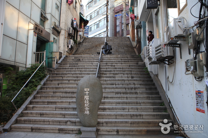
40-step Culture & Tourism Theme Street (40계단 문화관광테마거리)
2023-02-21
Area of 40gyedan-gil, Jungang-gu, Jung-gu, Busan
The 40-step Culture & Tourism Theme Street is a 450-meter street leading up to the 40-step stairway of the '40-step Cultural Center' and continues to the Palseong Tour.
The time-honored 40-step stairway embodies the joys and sorrows of refugees and those displaced by the Korean War. The entire area has been recently renovated to reflect life in Korea in the 50s & 60s.
The 40-step Culture & Tourism Theme Street was designated 'The Best Street' by the Busan municipal government in June 2004.

Spaland Centum City (스파랜드 센텀시티)
2026-06-10
35 Centum nam-daero, Haeundae-gu, Busan
Spaland Centum City has the merit of being both a traditional Korean-style public bath and an urban Japanese-style public bath. Spaland offers services tailored to customer's preferences by using carbonated and saline hot springs drawn from 1,000 meters underground. The facility consists of two floors and an outdoor spa. There are 22 baths including a kid's bath, 13 jjimjilbang facilities (Korean sauna), saunas, and an open-air foot bath. Noteworthy facilities include Roman Sauna, which is a recreation of an ancient Roman bath; a dry sauna where visitors can experience traditional Finnish-style saunas; and the Salt Room made with Himalayan salt. As such, Spaland features well-known sauna styles from different countries.Spaland enhances the effect of the hot springs by providing 100% natural hot spring water at varying temperatures. Its high-temperature bath rapidly increases one's body temperature, and the medium-temperature bath is good for a leisurely soak. The large public bath hall has windows allowing natural light, and the HVAC system is of hotel grade or higher. Visitors can relieve their stress while enjoying a healthy bath in a large-scale bath pool surrounded by nature.
Jamsil Hangang Park (잠실한강공원)
2024-03-13
65, Hangaram-ro, Songpa-gu, Seoul
Jamsil Hangang Park is a leisure space along the Hangang River, conveniently located near Lotte World. It features facilities such as the Jamsil Hangang Swimming Pool and the Jamsil Natural Learning Center, where visitors can observe various aquatic plants and fish. Additionally, there are volleyball courts, children's playgrounds, and walking trails. Visitors can also enjoy the Hangang River's night view from the observation deck café installed on Jamsildaegyo Bridge. There are also designated areas like Jungkook Forest No. 3, created to commemorate the 24th birthday of BTS member Jungkook and RM Forest No. 1.
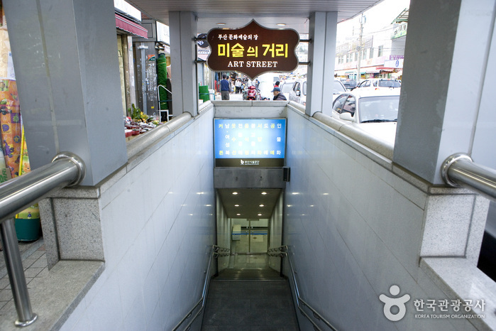
Gukje Market Art Street (미술의 거리)
2025-03-23
31, Junggu-ro, Jung-gu, Busan
Located in Jung-gu, Busan, Art Street was introduced in April 2005. It is the site of various art contests, exhibitions, cultural events, and special events related to the Pusan International Film Festival. It has also nurtured young artists and offered diverse artwork and art-related activities. As the focal point of cultural tourism in Busan, the street has contributed immensely to promoting culture and art in Busan.
Hwawon Oceano Tourism Complex (화원 오시아노 관광단지)
2026-06-30
552, Sia-ro, Haenam-gun, Jeonnam-Gwangju Special Metropolitan City
Set before the beautiful Korean archipelago, Hwawon Oceano Tourism Complex offers visitors a romantic beachside camping experience with a large campground and convenience amenities such as shower stalls. The campsite is particularly beautiful at sunset and night when stars fill the sky. Currently, the complex offers a golf course in addition to the campground, with plans to add a culture & arts center and marine world zone. Particularly, Pine Beach Golf Course located inside the tourism complex is surrounded by the ocean on three sides, and is perfect for playing a round of golf toward the endless ocean. The course is regarded as Asia’s Pebble Beach, a small coastal resort destination and home to famous golf courses in California.
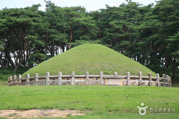
Tomb of King Wonseong (경주 원성왕릉)
2020-04-04
139, Singyeipsil-gil, Gyeongju-si, Gyeongsangbuk-do
+82-54-779-6100
The tomb of the King Wonseong, 38th king of the Silla Kingdom (785-798) in Oedong-eup, Wolseong-gun, Gyeongju is Historic Site No. 26. The tomb is 21.9m in diameter and 7.7m high and is encircled by a stone fence decorated with twelve oriental zodiac images. The area is also home to a number of stone monuments that stand facing each other: Hwapyoseok (marking the border of the tomb), Muninseok (civil servant statue), Muinseok (military officer image statue) and Dolsaja (a stone lion that protects the tomb). Muinseok in particular is a favorite among visitors because of its exotic appearance. The statue is sometimes compared to a strong and charismatic person of Arabic or Persian descendant, much like the merchants who came to Silla in ancient times.
Gwaereung is styled after tombs of the Tang dynasty, but still retains all the characteristics typical of Silla tombs; namely, the stones around the tomb, the 12 oriental zodiac figures, the protective walls, and the decorative stonework.
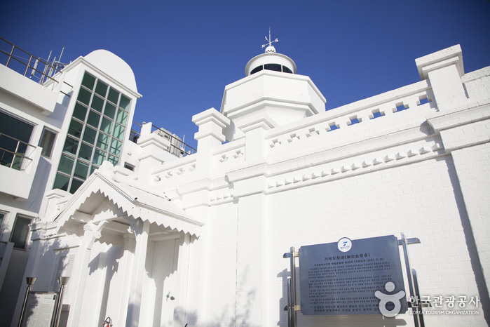
Gadeokdo Lighthouse (가덕도 등대)
2020-06-01
1237, Gadeokhaean-ro, Gangseo-gu, Busan
+82-51-971-9710
Gadeokdo Lighthouse is a manned lighthouse patterned after the gothic style of lighthouses in France. Built in December, 1909 at the end of the Daehan Empire (1897-1910), it is an intricate building that houses a light tower (9.2 meters high), an office, and a lighthouse keeper’s room. Plum blossoms, the symbol of the imperial family of Joseon, are delicately carved along this European-style building. It is considered a remarkable cultural property not only because of its architectural design, unique shape or historic value, but also because it has been surprisingly well-maintained, especially in comparison to other lighthouses built during the same period. In recognition of its unmatched style and preservation, the old Gadeokdo lighthouse was designated Tangible Cultural Property No. 50 of Busan in Sep. 2003. It is owned and managed by the Ministry of Maritime Affairs and Fisheries. A new lighthouse was built next to the original one in 2002. The new lighthouse structure is octagonal in shape and 40.5 meters high, the second highest lighthouse in Korea.
Gadeokdo Island, the location of Gadeokdo lighthouse, is often referred to as the ‘Island of History,’ and is the largest island in Busan. Gadeokdo, a strategically important base for military operations and seaborne trade, was the stage for a number of gruesome battles during the Imjin War (1592-1598). Today, it is a critical entry point to the Jinhae Bay.
Gadeokdo Lighthouse is located within a national naval base. Therefore, visitors must contact and register with the Busan Regional Maritime Affairs and Port Office prior to visiting the lighthouse. Those who participate in the Lighthouse Experience Program (parties of 6 or less) can spend the night in the innkeeper’s room free of charge. In order to use these accommodations, visitors must apply online at the Busan Regional Maritime Affairs and Port’s homepage between the 1st and the 8th of the month, one month prior to the desired date of visit.

Cheonho Park (천호공원)
2020-03-18
702, Olympic-ro, Gangdong-gu, Seoul
+82-2-489-2776
Located in Cheonho-dong, Cheonho Park is comprised of a musical fountain, an outdoor stage, and various sports facilities, making it the perfect spot for rest and leisure.
 English
 한국어
한국어 日本語
日本語 中文(简体)
 Deutsch
 Français
 Español
 Русский