Starpark (Chilgapsan Astrnomical Observatory) (칠갑산천문대 스타파크)
2024-02-23
178-46 Hantigogae-gil, Jeongsan-myeon, Cheongyang-gun, Chungcheongnam-do
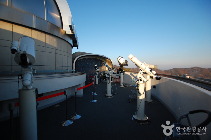
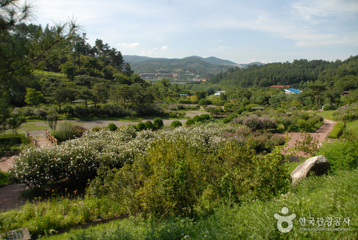
Starpark, also known as Chilgapsan Astronomical Observatory, is nestled within Chilgapsan Provincial Park in Cheongyang-gun, Chungcheongnam-do. This observatory is a science museum with a focus on astronomy and space, catering to both the general public and students. Conveniently, it's just a five-minute walk from the parking area. The facility is housed in a three-story structure. On the first floor, visitors can enjoy a three-dimensional dome theater and an audiovisual room. The second floor houses a publicity center and an observation deck. The observatory’s main observation room is on the third floor and features Korea’s largest refracting telescope (APO 304 mm), which is used primarily for viewing sunspots and prominences during the day. Additionally, there’s an auxiliary observation room equipped with Korea's first 180-degree hemispherical three-stage sliding system. This room is designed for nighttime stargazing and is fitted with a 400-milimeter reflecting telescope for observing planets, star clusters, and nebulae. Children are particularly fond of the 12-meter geo-massive astronomical projection room, where they can experience 5D images. For those wishing to extend their visit, accommodations are available at Namcheon-ri Sanchon Ecological Village or nearby Alps Village. Staying in these locations provides easy access to both the Chilgapsan Astronomical Observatory and the Cheonjangho Suspension Bridge, making for a comprehensive educational and recreational experience.
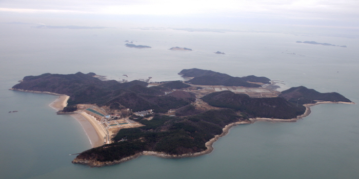
Daenanjido Island (대난지도)
2019-05-13
Nanji1-gil, Seongmun-myeon, Dangjin-si, Chungcheongnam-do
+82-41-350-3592
Nanjido Island gets its name from the fact that there are many orchids (‘nan’) and gromwells (‘ji’) on the island and because it is the largest of the islands in the area, the word ‘dae (big)’ is attached to the beginning of the name. The island is particularly famous for its fine sand beach and many sweetbriers. With close distance to Seoul and metropolitan areas, the island is visited by many people throughout the year.
The Nanjido Island area is an archipelago with eight islands (including Nanjido Island). A tour of the area offers the chance to view diverse sea landscapes as well as exceptional view of the sunset.
Bongsusan Recreational Forest (봉수산 자연휴양림)
2014-12-20
153, Imjonseong-gil, Daeheung-myeon, Yesan-gun, Chungcheongnam-do
+82-41-339-8936~8
Opened in 2007, the Bongsusan Mountain Natural Recreation Forest offers a variety of forest recreation facilities. The area is home to various wild birds. The forest also offers various hiking trails, which take between one and three hours to complete. The slopes are relatively gentle. Various rest and forest bathing sites are setup throughout the forest. The Yedang Reservoir is nearby, which is the nation’s top fishing ground. Also in the area is the Hyeongje (Brother) Park, Daeheung Dongheon, Daeryeonsa Temple, Imjonseong Fortress, Deoksan Hot Spring, Sudeoksa Temple, Chunguisa Temple, the residence of Chusa Kim Jung-hee, and the Korea Traditional Architecture Museum.
Yonghyeon National Recreational Forest (국립 용현자연휴양림)
2020-08-26
339, Maaesamjonbul-gil, Seosan-si, Chungcheongnam-do
+82-41-664-1978
Yonghyeon National Recreational Forest is situated in the heart of Yonghyeon Valley between the ridges of Gayasan Mountain around Seongmunbong Peak (alt. 678 m). The forest boasts splendid natural landscape. A hiking trail and loop trail through the forest are established along the ridges of the mountain and connect to the road leading to Seosan Farm, so hiking and walking are convenient and one can get a great view of the Yellow Sea in the distance. The valley waters are particularly clean and clear, and the forest features dense groves of oak trees. There are group accommodation facilities and forest education classes. For an educational and cultural excursion, visitors can also learn about the later Baekje period in a nearby education facility.
Geumgang Recreational Forest (Arboretum, Forest Museum) (금강자연휴양림(금강수목원,산림박물관))
2025-05-20
110, Sallimbangmulgwan-gil, Sejong-si
Along the river from Gongju toward Daejeon there is Geumgang River to the right. Following this river, there is a red arch-shaped bridge on the right called Bultigyo Bridge. Geumgang Recreational Forest, a large and well-organized forest, is located on the other side of this bridge. In the past, this remote village can only be reached by boat. In 1994, the Chungnam Forest Environment Research Institute moved to this area and designated the well-preserved dense forest as Geumgang Recreational Forest, and the Forest Museum opened in October 1997. Geumgang Recreational Forest is different from other recreational forests. Rather than a dense forest with a trail, this forest has a variety of attractions such as the Forest Museum, an arboretum, greenhouse, pond, and wildlife park scattered on well-maintained roads, giving the impression of a city park.
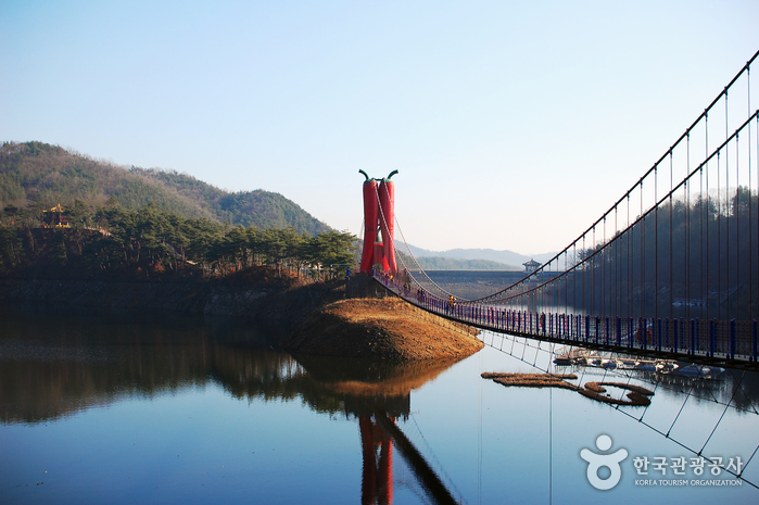
Cheonjangho Lake (천장호)
2025-01-13
24-23, Cheonjangho-gil, Cheongyang-gun, Chungcheongnam-do
Cheonjangho Lake is situated on the ridge of Chilgapsan Mountain about 11 kilometers away from the Chilgapsan Recreational Forest. This is reservoir of 1,200 hectares and is used to irrigate nearby farm land. Construction began in 1972 and took seven years to complete. The lake boasts clean water and an outstanding surrounding landscape. When it comes under fog or clouds, it creates a scenic view against the Chilgapsan Mountain landscape. In early spring, smelts are caught in abundance, drawing a growing number of tourists and anglers.
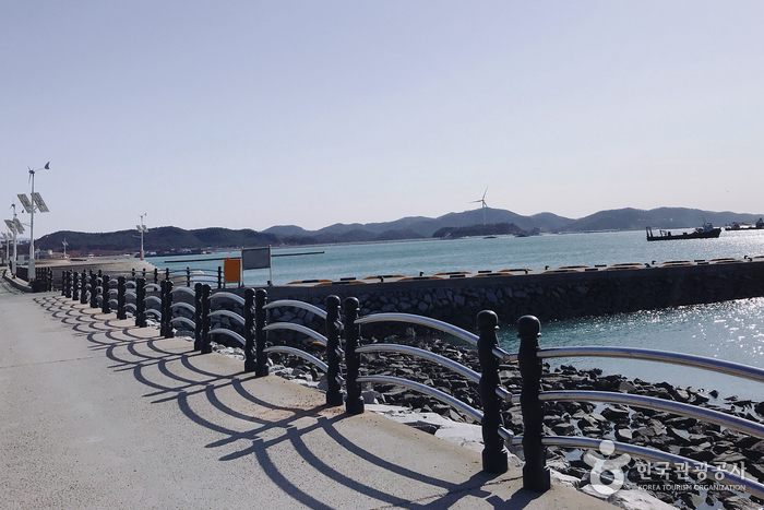
Boryeong Jukdo Island (죽도 (보령))
2021-06-02
408-54, Nampobangjoje-ro, Boryeong-si, Chungcheongnam-do
Although called Jukdo Island, the island today is technically not an island as it has been connected to the mainland since the construction of Nampo Embankment in 1999. Along the entrance of the island are many fresh hoe (sliced raw fish) restaurants lining the street. This unpopulated fishing island is also called Daeseom (Bamboo Island) for its dense groves of bamboo trees.

E-An Land (이안숲속)
2020-04-24
25, Sumogwon-gil, Gongju-si, Chungcheongnam-do
+82-41-855-2008
E-An Land Forest was established in 1999 when 1,836 arbor species and 1,418 herb species were planted on a land area of 1,118 hectares. The forest features a tropical garden and various other exhibition gardens, as well as thematic spaces like the Haneul Maru. The forest was finally completed in 2006. Inside the arboretum, there are various things to see such as the herb village, parakeet exhibitions, a pine tree garden, and man-made cave. There is also a mini golf course and an outdoor swimming pool. Visitors can also use the onsite pensions and the auto camping site for accommodation, making the E-An Land Forest a great place for family and group visitors.
Gobok Natural Park (고복자연공원)
2025-05-20
586, Dosingobok-ro, Sejong-si
Gobok Natural Park spans an area of 1,840,000 square meters and nearby attractions include a forest, Yonggul Cave, Sinheungsa Temple, and an outdoor sculpture park on Obongsan Mountain. A 3.65-kilometer-long deck circles the reservoir. The neighboring village is home to orchards for growing grapes, peaches, and pears. The park has a large meeting square and the outdoor sculpture park features works by Ewha Woman's University art professor Kang Tae-seong, attracting many visitors. The park is especially popular in summer when the outdoor swimming pool is open. In spring, people flock to Millakjeong Pavilion to view the cherry blossoms. There are many restaurants nearby specializing in galbi (ribs), Hanbang ori (duck with medicinal herbs), and megi maeuntang (spicy catfish stew), as well as cafes overlooking the natural scenery.
Cheoyongam (처용암)
2020-02-05
Hwangseong-dong, Nam-gu, Ulsan
+82-52-229-6350
Cheoyongam is a very small rocky island sitting in the middle of Gaeunpo Inlet in front of Saejuk Village in Hwangseong-dong, Nam-gu, Ulsan.
It is a historic islet related to the famous folktale of Cheoyong. The tale is about a dragon that emerged from the east sea along with his seven sons at the end of the Silla Kingdom (57BC - 935AD). One of the dragon’s sons named Cheoyong came to the capital and married a beautiful woman. One night, he found an evil spirit trying to attack his wife so he sang and danced, whereupon the spirit presented itself and kneeled in apology. Since then, people have used the image of Cheoyong to dispel evil spirits.
The dance that Cheoyong is said to have performed has been titled Cheoyongmu and has been designated as an Important Intangible Cultural Property. Cheoyongam is the sacred rock where the dragon in the tale is said to have appeared. There are many attractions nearby including Mokdo Island (Natural Monument No. 65), which offers magnificent lush greenery all year round.
 English
 한국어
한국어 日本語
日本語 中文(简体)
 Deutsch
 Français
 Español
 Русский