Rail Cruise Haerang (레일크루즈 해랑열차)
2020-07-06
405, Hangang-daero, Yongsan-gu, Seoul
+82-1544-7755
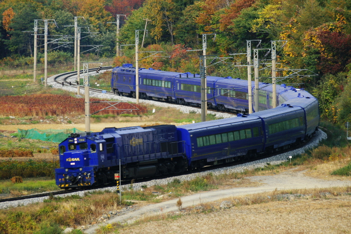
Rail Cruise Haerang, a hotel-on-wheels, began operating in November 2008 as the nation's first tourist train with sleeping accommodations. With a name meaning "together with the sun," Haerang is designed to be a luxury train similar to a yacht traveling along a beautiful mountain river beneath the bright sun. The exterior of the train is painted in a deep blue with gold lines and a logo featuring a phoenix while the interior design has Korean elements. Tourists will enjoy their time on the train, with personalized services and full amenities.
Gangneung Boksakkot Village (강릉 복사꽃마을)
2025-01-17
527-3, Sillicheon-ro, Gangneung-si, Gangwon-do
Gangneung Boksakkot Village blooms with peach blossoms each spring. The village is criss-crossed by Hacheon and Sillicheon Streams, which can be crossed by log bridges built long ago by the residents. These precious log bridges are sometimes removed for protection during the rainy summer season, and then put back out when the stream level lowers.
Boksakkot Village provides a wonderful glimpse into the rural agricultural lifestyle of Korea. Visitors can pick their own fruit directly from the tree to enjoy right away, as well as make a scarecrow or spread green tea fertilizer around the trees to help them grow. The village is also the venue for an annual peach blossom festival in April, and a scarecrow festival in August.
Yeonnam-dong (연남동)
2024-03-19
Yeonnam-dong, Mapo-gu, Seoul
Yeonnam-dong, located near Hongik University Station, has become a hot spot in Seoul as young artists and hipsters gather. It is densely packed with art spaces, and every alley is filled with unique concept cafés and many restaurants. There are also many guesthouses, editorial shops, and fashion stores, along with Yeontral Park, which was transformed from the old Gyeongui Line railroad into a park.
Whoo (后) SPA (후(后)스파)
2017-07-22
52, Hakdong-ro 21-gil, Gangnam-gu, Seoul
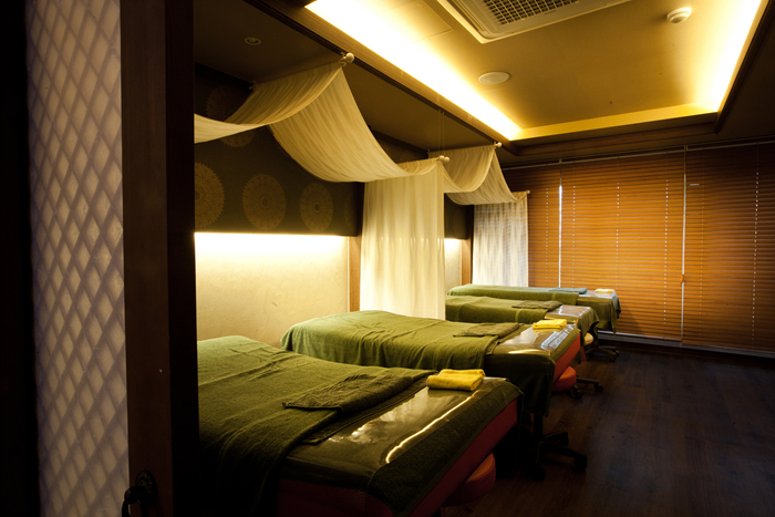
Whoo SPA is loved by celebrities throughout Asia. The spa uses advanced spa facilities and techniques for a powerful and peaceful healing experience. The treatments range from targeted areas to full body. Each treatment package comes with an expert spa therapist and a 1:1 spa consultation to provide the best service for each individual. Homecare samples may also be given for certain after-service treatments.
Hapjeong-dong Café Street (합정동 카페거리)
2024-03-19
415 Seogyo-dong, Mapo-gu, Seoul
Hapjeong-dong Café Street is a charming street near Hongik University Station lined with lovely cafés and restaurants offering cuisine from various countries. You'll find an abundance of unique cafés, including dessert cafés, bakeries, and nostalgic toy block cafés that evoke a sense of nostalgia. Some eateries specialize in single dish, while others offer exotic flavors from places like Hawaii and Africa, adding to the excitement of choice. During spring, you can enjoy a leisurely stroll along the cherry blossom-lined streets, creating a picturesque walking experience.
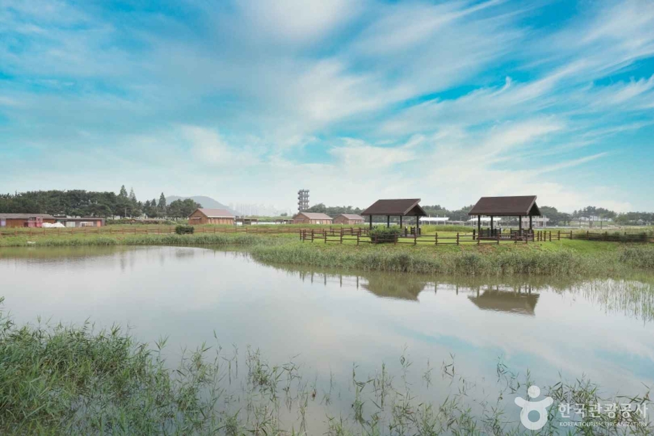
Siheung Gaetgol Eco Park (시흥 갯골생태공원)
2025-05-08
287 Dongseo-ro, Siheung-si, Gyeonggi-do
Siheung Gaetgol Eco Park in Gyeonggi-do features the nation's only inland beach along the shores of a river that ebbs and flows with the ocean tide. The park offers the chance to learn about the traditional salt-making techniques, as well as the many unique flora that grow here. The park was designated as a National Ocean Wetland Protection Zone in February 2012.
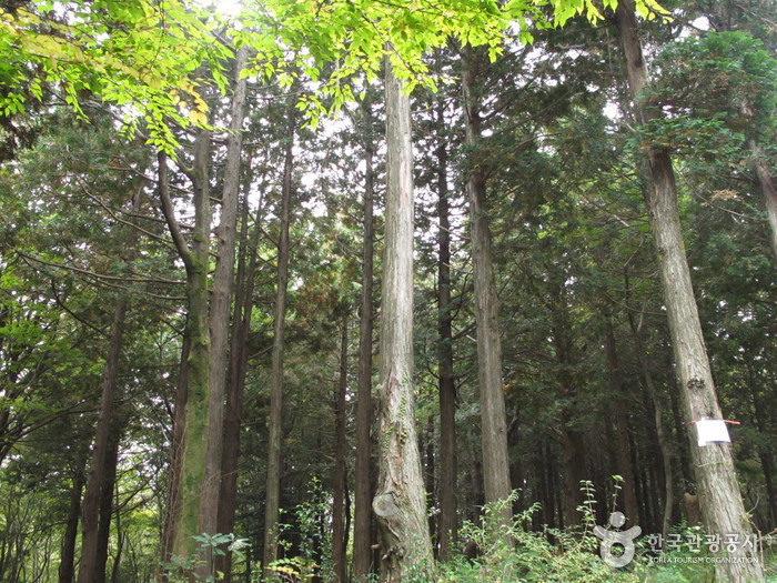
Seogwipo Recreational Forest (서귀포자연휴양림)
2020-08-13
882, 1100-ro, Seogwipo-si, Jeju-do
+82-64-738-4544
Seogwipo Recreational Forest is Korea’s southernmost recreational park that serves as an excellent nature getaway by preserving the mountain’s forest environment and ecosystem while minimalizing manmade structures as much as possible. The park is located approximately 700 meters above sea level, and is 10 °C lower in average temperature compared to that of Seogwipo’s downtown, providing the ideal condition to enjoy forest bathing and camping from spring to fall. The park is easily accessible by car, thanks to the paved road from the mountain’s foothills all the way up to the park’s entrance. It takes about 30 minutes by car from Seogwipo’s downtown to the recreational park. The park is densely packed with trees and the air is filled with the refreshing forest scent, and even has a pebble walking trail suitable for a barefoot massage. The forest is equipped with amenities such as a mountain cottage, forest bathing site, campfire site, cooking area, and auto-camping site. Although the amenities serve to provide visitors’ convenience, they are minimized so as to prevent damage to the forest’s natural environment.
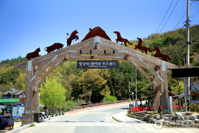
Jeongnamjin Cypress Forest Woodland (정남진 편백숲 우드랜드)
2025-10-23
180, Woodland-ro, Jangheung-gun, Jeollanam-do
Jangheung Jeongnamjin is an ecological village situated next to mountains, the sea, and the river. The Jeongnamjin Cypress Forest Woodland is the best spot in the area to enjoy the refreshing air and a forest full of tall, 40-year-old cypress trees. Sitting at the foot of Eokbulsan Mountain overlooking downtown Jangheung-eup, the Jeongnamjin Cypress Forest Woodland is home to the Wood Culture Experience Hall, beautiful lodging facilities, including hanoks (traditional Korean houses), the Jeonnam Woodcraft Center, the Ecological Building Experience Site, Forest of Therapy, and the Cypress Salt House (traditional Korean sauna).
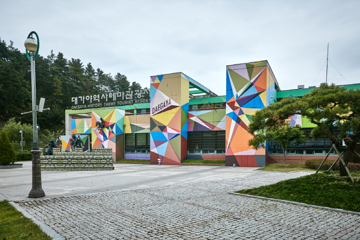
Daegaya History Theme Park (대가야 역사테마관광지)
2023-03-07
1216, Daegaya-ro, Goryeong-gun, Gyeongsangbuk-do
Daegaya History Theme Park is located in what was the center of the Daegaya Kingdom. The park offers various areas to learn about not only the history of the area but also the current culture and the future of Goryeong. In particular, visitors can enjoy various items produced during the Daegaya era such as pottery, ironworks, and gayageum (traditional Korean string instrument), as well as visit the park's 4D theater and walk along the forest exploration trail.

Sehwa Beach (세화해변)
2023-01-17
Sehwa-gil, Jeju-si, Jeju-do
Sehwa Beach, located in Sehwa-ri in Gujwa-eup, is a white sandy beach with black basalt that harmonizes perfectly with the emerald waters. Sehwa Beach is well-known in Jeju Island due to its close proximity with Bellongjang Market and Sehwa Folk Fifth-day Market, opening right next to Sehwa Beach, as well as the flea market at Bellongjang Market attracting many visitors.
 English
 한국어
한국어 日本語
日本語 中文(简体)
 Deutsch
 Français
 Español
 Русский