
Seongsu-dong Handmade Shoes Street (성수동 수제화거리)
2025-03-15
15, Yeonmujang 7-gil, Seongdong-gu, Seoul
Handmade shoe manufacturers began to gather in the 1970s to form a street and make history. Today, there are some 350 handmade shoe manufacturers, 100 intermediate processing and raw materials companies, and new cafes with unique vibes opening up one after another. Thanks to its vintage appeal, many people visit on dates and to take cool photos.

Hanbyeok Tunnel (한벽터널)
2025-11-05
2 Girin-daero, Wansan-gu, Jeonju-si, Jeonbuk-do
A number of romanic and heartwarming scenes were filmed in the Hanbyeok Tunnel surrounded by ivy in the drama series "Twenty-Five Twenty-one." This place often appeared in scenes where to two main protagonists encouraged each other or soothed pain. It also appeared in the scene where the two broke up.
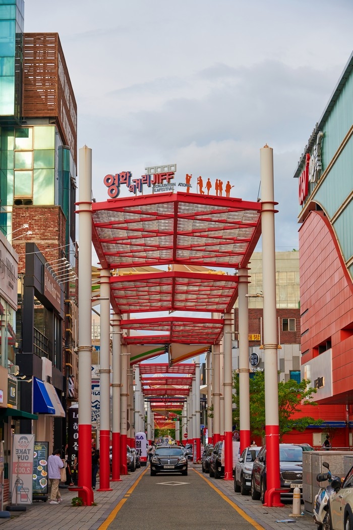
Jeonju Movie Street (전주 영화의 거리)
2025-11-05
Gosa-dong, Wansan-gu, Jeonju-si, Jeonbuk-do
Jeonju Movie Street is the venue of Jeonju International Film Festival that is connected to Gaeksa Street, a representative shopping street in the original downtown of Jeonju. Gaeksa Street has a unique atmosphere where various shops and cute cafes are combined with buildings showing traces of time. When the Jeonju International Film Festival is held, the red-colored streets become more dynamic with crowds from all over the country to watch movies.

Gamaksan Suspension Bridge (감악산 출렁다리)
2024-11-26
238 Seolmacheon-ro, Jeokseong-myeon, Paju-si, Gyeonggi-do
Gamaksan is one of five great mountains of the Gyeonggi region, and according to legend, its name means a dark blue-colored rocky mountain whose rocks emanated black and blue lights at the same time. The suspension bridge located at the starting point of the Gamaksan Trail connects Seolmari Valley, which had been severed by a road, to make Gamaksan into a single mountain again. It is 150 meters long, which makes it the nation's longest bridge tower-less suspension bridge, and was constructed to form harmony with nature.
Gamaksan boasts small but beautiful valleys around Seolmacheon Stream as well as Ungyepokpo Falls where the waterfalls are nearly vertical so it is used for ice wall training in the wintertime. Gamaksan Stele sits at the top and, just underneath Janggunbong Peak lies Imkkeokjeonggul Cave where Im kkeokjeong is known to have hidden away from the pursuit of the government army. Gamaksan is close to the ceasefire line so, once you climb up to the peak, you will be able to see the Imjingang River and Songaksan Mountain in Gaesong. Fresh scents of pine trees and soil on the trails and mountain ridges attract countless climbers.
Imjingang Hwangpo Sailboat (임진강 황포돛배)
2023-02-02
1857, Yulgok-ro, Jeokseong-myeon, Paju-si, Gyeonggi-do
A Hwangpo sailboat quietly floats on the Imjingang River moving with the wind with its broad and yellow sail stretched out. Hop on a Hwangpo sailboat, which was a major means of transportation in the Joseon Dynasty, and enjoy the beauty of the red cliffs of Imjingang for about 45 minutes from Duji-ri to Jajang-ri. Paju Hwangpo Sailboat has fully recreated the original form from the Joseon Period and presents tourists with the excitement of traveling back in time. Once you board a Hwangpo sailboat and depart from Duji Quay, you will be able to immerse yourselves into the gorgeous landscape of Imjingang, from the red cliffs in Wondang-ri and Horogoruseong Fortress to Gorangpo Yeoulmok, where civilian access was restricted for several decades.
Yulgok Arboretum (율곡수목원)
2023-02-02
392, Jangseungbaegi-ro, Papyeong-myeon, Paju-si, Gyeonggi-do
Yulgok Arboretum was established for the preservation, proliferation, and exhibition of plant genetic resources, and provides a variety of resort services related to forest culture for citizens. It features a four seasons garden, conifers garden, rock garden, fruit tree garden, Saimdang Forest, and many other beautiful venues, and also offers diverse forest experiences. It also provides a forest experience program for infants and toddlers as well as a forest healing program in which people of all ages and genders may participate. The Dulle Trail surrounding the arboretum runs some 5 kilometers in length and exudes diverse views from its observatory, pine scent path, and Munbawi Rock. From the arboretum, you will be able to see the Imjingang River to the north and great mountains such as Papyeongsan and Gamaksan to the east. It is possible to tour the historical sites of Yulgok Yi I and Hwang Hui as well since they are close by.
Gimpo Daemyeong Port (김포 대명항)
2023-02-02
109, Daemyeonghang 1-ro, Daegot-myeon, Gimpo-si, Gyeonggi-do
The piercing smell of salt, the energy of freshly caught fish, fishing boats returning from far out at sea, and people walking in and out of the fish market and raw fish restaurants - these are the scenes of Daemyeong Port in Daegot-myeon, Gimpo where the fresh vigor of life is vividly alive. It is located just 30 minutes from Gimpo Airport by car so it is close to Seoul. Fishermen and owners of fishing boats personally run raw fish restaurants so the prices of raw fish are about 20% cheaper here than at other ports, according to the people of Daemyeong Port. Raw fish restaurants that you first encounter at the entrance of the port have tanks filled with freshly caught fish, and fishing nets spread out here and there vividly show the unique characteristics of a port. As it is the only port on the coast of Ganghwado Island, you are able to fully enjoy the beautiful seascape. The port is also receiving a great deal of attention both locally and nationwide thanks to the Daemyeong Type 2 Fishery Harbor project and the Pungeoje Festival. In 2001, Daemyeong Port was selected as one of the "7 Winter Seas recommended by the Korea Tourism Organization" for its beautiful seascape and flavors of a traditional port. Facing Ganghwado across Ganghwa Strait, Daemyeong Port is not as busy with tourists as Sorae Port or Yeonan Pier and boasts quiet and affectionate scenes of a fishing village. Nearby lies Deokpojin Fort, which is a historical site where our ancestors in the late Joseon Dynasty fought against foreign forces.
Laveniche Plaza (라베니체광장)
2023-02-02
810, Taejang-ro, Gimpo-si, Gyeonggi-do
Hangang Central Park, which was constructed as a result of the development of Gimpo Hangang New City, boasts a fabulous trail from the Golden Waterway by the waterside path all the way to Laveniche Shopping District. Golden Waterway Laveniche continues along a 2.68-kilometer-long trail and displays a variety of sceneries from the south to the north. Designed after Venice, the city of water, Laveniche features many different shops along the water that runs 1.7 kilometers for a round trip. Various living goods shops, restaurants, and pubs are set up on both sides of the water near the Central Plaza so it is a perfect place to spend time healing after a light stroll and shopping.
Hangang Jungang Park (한강중앙공원)
2023-02-01
40, Chodang-ro, Gimpo-si, Gyeonggi-do
Hangang Jungang Park, a famous park in Janggi-dong that represents Gimpo New City, features a wildflower garden with the theme of native plants as well as a variety of spring flowers in Chohwawon Garden and a pleasant trail. Continuing from a vast grass plaza to Laveniche Waterside Park, this park is where the citizens of Gimpo New City can rest and relax. As you run along the Golden Waterway, you will be able to reach Laveniche, another pride of Gimpo with abundant things to eat, buy and enjoy. You can also take a leisurely walk, jog, or ride a bicycle.
Seongsu-dong Cafe Street (성수동 카페거리)
2024-10-28
Seongsu-dong, Seongdong-gu, Seoul
Yeonmujang-gil in Seongsu-dong, known for old factories and a shoe workshop street, has been reborn as a place of trendy cafes and culture. The energy of car repair shops, printing factories, and handmade shoes street still exist today but, as global restaurant brands, select shops, and cafes have set up amidst busily operating factories, an atmosphere unique to Seongsu-dong has been created. "Daerim Warehouse" led to the change in the Seongsu-dong streets and can be said to be the originator of all warehouse-style cafes that are popular throughout Cafe Street today. The red-brick structure, antique signboards, and a vast indoor space of an old warehouse have been maintained and, with the addition of a sensuous interior design, it has become a space suitable for fashion shows and exhibits, thus showing new potential for old Seongsu-dong architecture. Every day, new cafes, bakeries, restaurants, and cultural complexes open their doors and are busy welcoming visitors.
 English
 한국어
한국어 日本語
日本語 中文(简体)
 Deutsch
 Français
 Español
 Русский