Bangeojin Port (방어진항)
11.9Km 2025-01-10
2 Seongkkeut-gil, Dong-gu, Ulsan
+82-52-209-3534
Bangeojin Port, designated as a national fishing port in 1971, is Ulsan's representative fishing port, with a large site for a fisheries cooperative's commission and an auction house. Various fish species, such as yellowtail, cutlassfish, Spanish mackerel, and anchovies, are caught. You can purchase fresh seafood from a nearby fish market or sashimi restaurant and enjoy it immediately.
The promenade along the breakwater reaches Seuldo Lighthouse, an excellent photo spot, and the sea road leading to Bangeojin Port, Daewangam Park, Ulgi Lighthouse, and Ilsan Beach also boasts romantic scenery. Recently, to revitalize tourism resources, murals and floor designs for the northern breakwater, parking lots, etc., were developed, and a village museum, the Bangeojin Museum, was opened. It serves as a resting place for Ulsan citizens and provides many attractions for tourists.

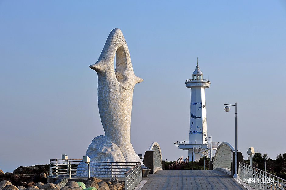
Seuldo Island (슬도)
12.6Km 2023-01-03
Bangeo-dong, Dong-gu, Ulsan
+82-52-277-0101
Seuldo Island is located off the coast of Ulsan City in the southeastern part of the Korean Peninsula.
Its name, Seuldo ("seul" meaning the Korean stringed instrument geomungo), was given as the sound of wind and waves hitting the rock island is said to mimic the sound of geomungo. In fact, the sound of waves hitting the island is so good that it is called seuldomyeongpa or the resounding of waves.
The island is also known as Siruseom ("siru" meaning an earthenare steamer) for its resemblance to the upside down siru, and Gomboseom ("gombo" meaning pockmarks) for its stones with holes in them.
On the island, there is an unmanned lighthouse dating back to the late 1950s. The main economic activity on the island is fishery.
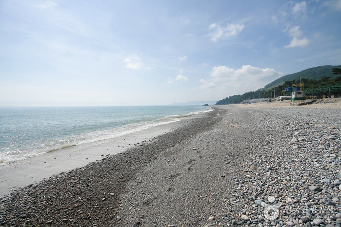
Gwanseong Solbat Beach (관성솔밭해변)
14.0Km 2021-08-12
68-24, Yangnam-ro, Gyeongju-si, Gyeongsangbuk-do
+82-54-779-6325
Gwanseong Solbat Beach, formerly Gwanseong Beach, is known for its extremely clean waters, and the connecting pine grove creates a gorgeous semi-circle shape. Nearby in Sindae-ri, Yangnam-myeon is Kolon Garden Golf Club, allowing visitors to enjoy many other leisure activities in the area. The driving course along the coastal road is also popular among visitors.
![Petroglyphs of Cheonjeon-ri [UNESCO World Heritage] (울주 천전리 명문과 암각화 [유네스코 세계유산])](http://tong.visitkorea.or.kr/cms/resource/14/3335114_image2_1.jpg)
Petroglyphs of Cheonjeon-ri [UNESCO World Heritage] (울주 천전리 명문과 암각화 [유네스코 세계유산])
15.9Km 2025-07-18
Cheonjeon-ri, Dudong-myeon, Ulju-gun, Ulsan
The petroglyphs (figures, pictures, and letters were made on the rocks along the mid-stream area of Naegokcheon Stream, which is a tributary of Taehwagang River. The upper and lower sides of the rocks contain petroglyphs that differ in the content and techniques used. The upper side contains petroglyphs made by means of chiseling. The inscriptions include geometric patterns, animals, and abstract human figures. There are concentric circles, with a round figure looking like the sun at the center, four running deer next to them, and several semi-human animals. The figures with simplistic expression and symbolism appear to have been made during the Bronze Age.
The lower side contains line-drawn picture mixed with Chinese characters. They include a procession of horse riders, animals including dragons, and boats. In particular, the procession of horse riders appears in three different places. The boats provide researchers with important information on the offshore activities carried out by people of the Silla dynasty. The 800-plus written characters are about the King and Queen’s visit to the place. They were presumed to have been inscribed on two occasions during the reign of King Beopheung (r. 514-540) of the Silla dynasty. The content on the official positions and the government system makes it a precious material for those studying Silla during or around the 6th Century. The petroglyphs were made by many people over an extended period of time, providing vivid information on the life and thoughts of people from prehistoric times to the Silla dynasty.
The petroglyphs in Cheonjeon-ri and petroglyphs on the Bangudae Terrace, spanning three kilometers altogether along the Bangucheon Stream, have been inscribed on the UNESCO World Heritage List on July 12, 2025.
(Source: Korea Heritage Service)
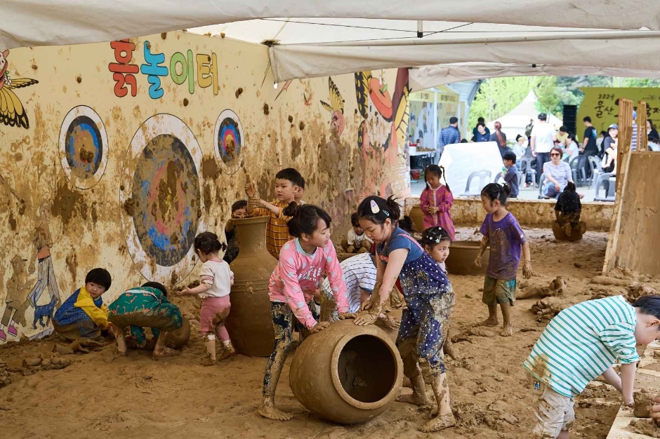
Ulsan Onggi Festival (울산옹기축제)
16.0Km 2025-07-11
36 Oegosan 3-gil, Onyang-eup, Ulju-gun, Ulsan
+82-52-980-2233
Ulsan Onggi Festival is held annually in early May in Oegosan Onggi Village in Ulju-gun, renowned for its traditional onggi (earthenware)-making techniques. The festival promotes the regional specialty, onggi, contributing to the spread of everyday onggi and the development of traditional industries. The main event, “Touch of the Onggi Master,” features demonstrations by master onggi artisans from Oegosan. There are various hands-on activities for children, including stepping on clay, playing with clay, and making and firing onggi. Visitors can also learn about the uses of onggi in food storage and fermentation, and view onggi from around the world. Don’t miss the opportunity to taste local specialties and foods from Ulju.
◎ Onggi
Onggi is a type of bowl crafted from soil, using water, fire, and wind. This traditional pottery has been produced since the Three Kingdoms period and is well-suited for long-term food storage due to its excellent ventilation and preservative capabilities.
Ulsan Daegok Museum (울산대곡박물관)
16.7Km 2021-05-18
257, Seohacheonjeon-ro, Ulju-gun, Ulsan
+82-52-229-4787
Ulsan Daegok Museum displays artifacts that were uncovered from the area of Daegok-ri during the construction of Daegok Dam. Approximately 13,000 relics were excavated during land inspection prior to the dam construction, including Hasamjeong Ancient Tomb. These findings were collected and became available for public display when the museum opened on June 24, 2009.
Padosori Trail (파도소리길)
17.3Km 2025-05-28
405-7 Eupcheon-ri, Yangnam-myeon, Gyeongju-si, Gyeongsangbuk-do
The Padosori (Sound of the Waves) Trail stretches for 1.7 kilometers along the shoreline of Eupcheon-ri in Gyeongju, offering stunning views of the Gyeongju Yangnam Columnar Joint. The coastal road is well-maintained and features a decked pathway, benches, viewing platforms, and a suspension bridge. The Columnar Joint has diverse shapes; in particular, the fan-shaped columnar joint is a rare sight not only in Korea but also worldwide, and thus has been designated as a Natural Monument in 2012.
Gyeongju Yangnam Columnar Joint Observatory (경주 양남 주상절리 전망대)
17.4Km 2023-04-04
498-13 , Donghaean-ro, Gyeongju-si, Gyeongsangbuk-do
+82-54-775-6366
This observatory was built in October 2017 and allows visitors to enjoy the view of columnar joints of Yangnam, a national geopark. The columnar joints are formed along the shoreline of Eupcheon-ri in Yangnam-myeon. Several different forms of columnar joints can be observed from columnar joints that point upward to those that fan out or lean to the side. In particular, the fan-shaped columnar joint is a rare sight not only in Korea but also worldwide, and thus has been designated as a Natural Monument in 2012. Visitors can also see informational exhibits on diverse geographical resources at the observatory as well as ask for a detailed guide by the geology commentator on-site.
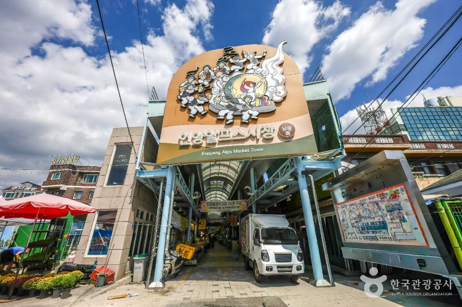
Eonyang Alps Market Town (언양알프스시장)
19.7Km 2025-12-17
12-1 Jangteo 1-gil, Eonyang-eup, Ulju-gun, Ulsan
052-262-1545
Eonyang Alps Market Town is a medium-sized market established in 1915, held on days ending in 2 and 7 of each month. In the past, it was called the “Seven Towns Market” because products from seven nearby areas, including Cheongdo, Dongnae, Yangsan, Gyeongju, Yeongcheon, and Ulsan, were gathered here. About 40 years ago, the market took its current form and now operates as a general market.
 English
 한국어
한국어 日本語
日本語 中文(简体)
 Deutsch
 Français
 Español
 Русский