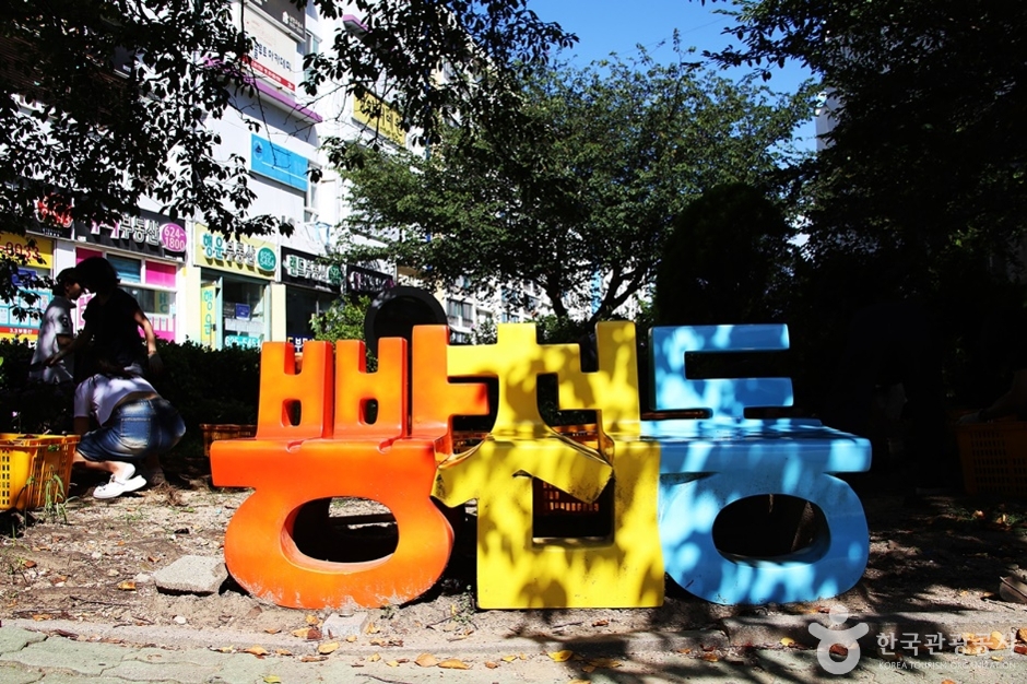
Ppangcheon-dong (빵천동)
7.5Km 2025-08-05
Namcheon-dong, Suyeong-gu, Busan
Located in Namcheon-dong and originally known for its cherry blossom street, the neighborhood has gained a new nickname, “Ppangcheon-dong”, as local bakeries have begun attracting visitors specifically for their bread. The alley is lined with both long-standing local favorites and trendy, unique bakeries, making it a perfect place to savor the aroma while taking a leisurely stroll and trying different kinds of breads. Its proximity to Gwangalli Beach, one of the most popular attractions of Busan, makes it an ideal destination to visit together.

Olive Young - Dadaepo Harbor Station Branch [Tax Refund Shop] (올리브영 다대포항역점)
7.6Km 2024-06-26
#104, 550, Dadae-ro, Saha-gu, Busan
-
Yeongdo Lighthouse (영도 등대)
7.6Km 2024-03-06
181, Jeonmang-ro, Yeongdo-gu, Busan
+82-51-405-1201
Yeongdo Lighthouse, first lit in 1906, stands at Taejongdae Park. It houses a maritime library, galleries, an observatory, and a café. From the observatory, on clear days, you can even see as far as the Japanese island of Tsushima Island. At the base of the lighthouse, there's a sculpture of a woman turned into stone, waiting for her husband who went out to sea. You can reach it by walking from Taejongdae Park or taking the Taejongdae Danubi Train.
![Olive Young - Namcheon Station Branch [Tax Refund Shop] (올리브영 남천역)](http://tong.visitkorea.or.kr/cms/resource/18/2885718_image2_1.jpg)
Olive Young - Namcheon Station Branch [Tax Refund Shop] (올리브영 남천역)
7.7Km 2024-04-18
384, Suyeong-ro, Suyeong-gu, Busan
-
Olive Young - Busan W Square Branch [Tax Refund Shop] (올리브영 부산W스퀘어점)
7.8Km 2024-06-27
#1004 and #1005, 145, Bunpo-ro, Nam-gu, Busan
-
Jangnim Port (장림포구)
7.8Km 2023-02-06
72, Jangnim-ro 93beon-gil, Saha-gu, Busan
+82-51-220-4502
Jangnim Port is a trending place in Busan that has gained popularity through word of mouth on social media. Administratively, it belongs to Jangnim-dong, Saha-gu, and the name of the port is Jangnim Port after the neighborhood. Because the colorful buildings and small boats floating along the port resemble Venice's Murano Island, its nickname is "Bunezia," meaning Busan's Venice. Due to its beautiful sunset and location on the way to Dadaepo Beach, Jangnim Port has emerged as a new summer resort in Busan, as it is possible to tour in connection with the Amisan Observatory and the Dadaepo Sunset Fountain of Dreams.
Oryukdo Skywalk (오륙도 스카이워크)
7.9Km 2025-04-15
137 Oryukdo-ro, Nam-gu, Busan
Oryukdo Skywalk is located at what was called Seungdumal, meaning a saddle, due to the shape of the point. It was also called Jallokgae by residents and female divers in the area.
The construction of Oryukdo Skywalk began on September 12, 2012, at the Seungdumal area, which is regarded as the dividing point between the East Sea and the South Sea, and the skywalk opened on October 18, 2013, with the theme of "walking over the sky.”
Iron columns were set up over a 35-meter-high coastal cliff, and a 15-meter glass bridge comprised of 24 glass plates and shaped like a horse’s hoof connect the iron columns. The glass flooring was made by four layers of 12-millimeter glass panels coated with a bulletproof film for a total thickness of 55.49 millimeters, making the structure quite safe. Visitors will be thrilled with the view of the waves while looking down through the transparent floor. The sea stretches out ahead of the skywalk, perfect for a photo op.
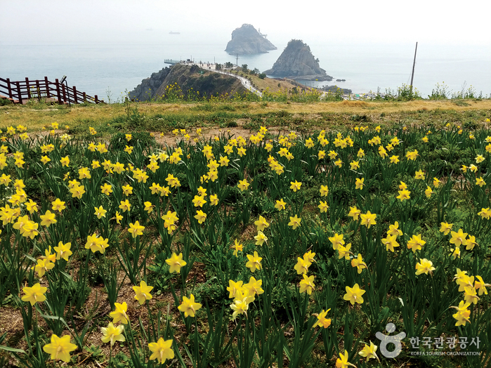
Oryukdo Sunrise Park (오륙도해맞이공원)
7.9Km 2025-01-20
Yongho-dong, Nam-gu, Busan
Oryukdo Sunrise Park, situated in the Yongho-dong area of Busan, offers a breathtaking view of the vast sea, especially in spring when the fields are covered with daffodils and canola flowers. Oryukdo Skywalk, a 15-meter-long glass bridge above the sea, provides the best view of Oryukdo Islets. This is also the place where the East Sea and the South Sea meet, known as Jallokgae or Seungdumal. Visitors can find a signboard below the skywalk marking the point where the east and south sea meet. From here, the Haeparang Trail stretches 770 kilometers along the East Sea and Namparang Trail stretches 1,463 kilometers along the South Sea.
Oryukdo Islets (Busan National Geopark) (오륙도 (부산 국가지질공원))
7.9Km 2024-03-05
137 Oryukdo-ro, Nam-gu, Busan
+82-51-888-3636
Oryukdo Islets consists of six rocky islets located in the sea at the southern end of Igidae Park, appearing as either five or six depending on the tide. The islets, closest to the mainland, are named Bangpaeseom Island, Solseom Island, Suriseom Island, Songgotseom Island, Gulseom Island, and Deungdaeseom Island, with only the Deungdaeseom Island accessible to visitors. From the Oryukdo Skywalk at Oryukdo Sunrise Park, visitors can enjoy even better views of the islets.
Haeparang Trail Course 1 (해파랑길 1코스)
7.9Km 2023-02-03
137, Oryukdo-ro, Nam-gu, Busan
+82-51-607-6395
The first course of Haeparang Trail is a coastal road connecting Yongho-dong, Nam-gu and Jung 2-dong, Haeundae-gu in Busan, starting from Oryukdo Sunrise Park, passing Gwangallihaebyeon Beach and APEC Beach, to Mipo. Not only can visitors enjoy the sea cliffs and the natural scenery of the East Coast, but also the splendid and bustling Gwangalli and Haeundae tours.
 English
 한국어
한국어 日本語
日本語 中文(简体)
 Deutsch
 Français
 Español
 Русский