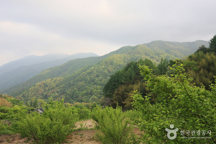
Jirisan National Park (Hadong Section) (지리산국립공원(하동))
13.3Km 24078 2021-06-24
Hwagae-ro, Hadong-gun, Gyeongsangnam-do
+82-55-883-1750
Designated as the first national park in Korea on December 29, 1967, Jirisan National Park stretches out over 483.022 square kilometers, making it the largest national park among all 22 national parks. It covers Korea’s three southernmost provinces; Gyeongsangnam-do, Jeollanam-do, and Jeollabuk-do, one city, four counties, and 15 districts of eup and myeon. The area in Gyeongsangnam-do has many temples including Ssanggyesa Temple and Chilbulsa Temple, as well as valleys, falls, and other tourism resources.
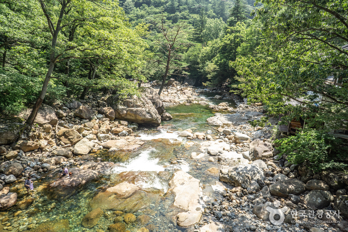
Daewonsagyegok Valley (대원사계곡)
13.3Km 46018 2021-02-24
Samjang-myeon, Sancheong-gun, Gyeongsangnam-do
+82-55-970-7201
Daewonsagyegok Valley is a place where one can be appreciate nature's musical harmony of stream water, wind brushing against the leaves, and the chirping of birds. The nearly 12-kilometer-long Daewonsagyegok Valley's stream water originates from the highest peak of Jirisan Mountain called Cheonwangbong Peak, and flows through Jungbong and Habong Peaks, as well as Ssukbatjae Pass, Saejae Pass, Wangdeungjae Pass, Bammeorijae Pass, and Ungseokbong Peak. Before reaching the valley, the water joins the currents from Sinbatgol, Jogaegol, and Bambatgol Valleys. The volume of water increases as it passes Saejae and Oegok Village and reaches Yupyeong-ri where Daewonsa Temple is located. The incessant sound of running water fills the silence of the forest as if Buddhist nuns were chanting blessings.
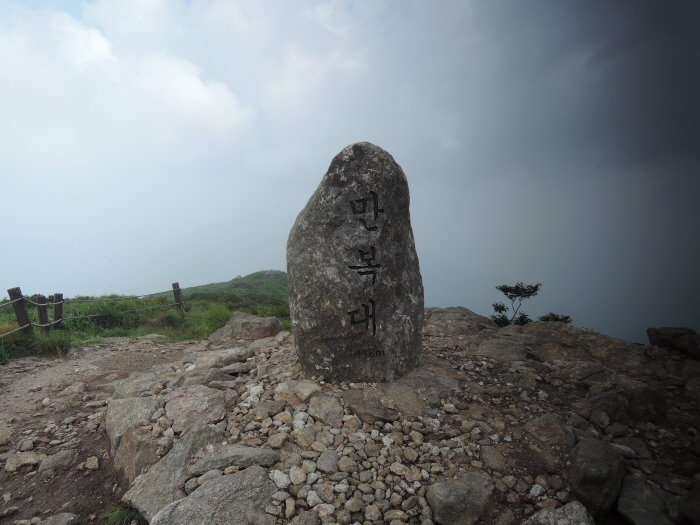
Jirisan Manbokdae Peak (지리산 만복대)
13.5Km 24999 2021-02-05
Sandong-myeon, Gurye-gun, Jeollanam-do
+82-61-780-7700
Manbokdae Peak in the west soars at the boundary between Sandong-myeon, Gurye-gun and Namwon-si at 1,433.4 meters above sea level. ”Man” means “full of something” and “bok” means “fortune.” Like the name, Manbokdae is considered as a fortunate mountain with great views as it is surrounded by smooth hills. According to an old story, Manbokdae Peak was chosen as one of the 10 scenic areas, where people come to receive good fortune.
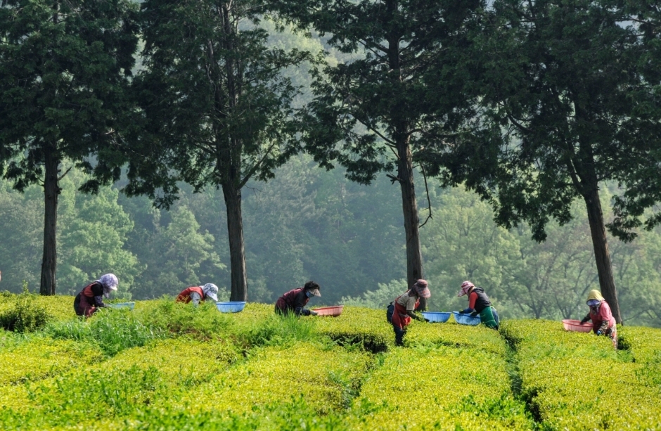
Hadong Wild Tea Cultural Festival (하동 야생차문화축제)
13.9Km 25614 2023-05-17
571-25, Ssanggye-ro, Hadong-gun, Gyeongsangnam-do
• 1330 Travel Hotline: +82-2-1330 (Korean, English, Japanese, Chinese) • For more info: +82-55-880-2052~4
Hadong Wild Tea Cultural Festival is held every May in Hadong, where tea cultivation started approximately one thousand years ago. Grown in an area with the perfect conditions for tea cultivation, the green tea from Hadong was called “the King’s green tea.” Hadong Wild Tea Cultural Festival offers visitors various exhibitions and programs with high-quality teas.

Jirisan National Park (Namwon) (지리산국립공원(남원))
14.0Km 21790 2024-04-07
255 Jeongnyeongchi-ro, Jucheon-myeon, Namwon-si, Jeonbuk-do
+82-63-630-8900
Jirisan National Park is the second-highest mountain in South Korea, standing at an elevation of 1,915 meters, spanning across the provinces of Gyeongsang-do and Jeolla-do. Revered as a sacred mountain alongside North Korea's Baekdusan Mountain, it is home to the Asiatic Black Bear and features numerous peaks, including Cheonwangbong Peak. In spring, various flowers such as Royal Azalea bloom, while lush forests thrive in summer, vibrant foliage adorns the landscape in autumn, and the winter scenery boasts snow-covered peaks and icy landscapes.
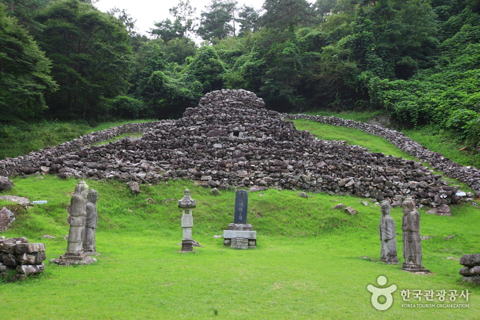
Tomb of King Guhyeong, Sancheong (산청 전 구형왕릉)
14.7Km 18145 2020-06-30
Guhyeongwangneung-ro, Sancheong-gun, Gyeongsangnam-do
+82-55-970-6411
This stone grave is known to be the tomb of King Guhyeong, the 10th King of the Gaya Kingdom. He is also known as King
Guhae or King Yang, and is the grandfather of Kim Yoo Shin. Since becoming
the King of Gaya in 521 AD, he reigned for 11 years until he handed over his
country to King Beopheung of the Silla Kingdom in 532 AD.
There are two
different scholarly opinions about this tomb. One is that it should be classified as a stone pagoda and the
other, a royal tomb. The reason why this was regarded as a pagoda is
that there are similarly shaped stone pagodas in the Andong and Uiseong regions.
The basis for it being called Wangreung, or royal tomb, is that there is a record in Dongguk Yeoji Seongram (an
ancient history book published during the rule of King Seongjong in the Joseon dynasty) and
in Saneum-hyeon Sancheonjo (a record of events in the region) of it being a
tomb. The
notes state that "there is a structure with steps on
the four faces, in the form of nine dragons piled up of stones at a distance
of about 16 km (40 ri in traditional Korean scale) from the village, so
people believe it must be a royal tomb".
The record describing the name of the king buried
in this tomb can be extracted from a record of travels called Wangsan Shimreunggi
written by Hong Ui Young, a Joseon dynasty scholar. In addition, there’s also
an entry in Wangsansagi, a book on the history of Wangsansa Temple (a
temple located west of the tomb) that the person buried in the tomb is King Guhyeong.
Unlike ordinary
graves, the tomb is built at the middle part of the hill's slope. The tomb
has a unique appearance made up of steps and layers, with the highest point
being 7.15 meters high. There are seven layers at the front and no steps at
the back due to it being built on an inclined surface. The overall shape of
this tomb is different from the pyramids built on level ground. The top of the tomb is oval in
shape. At the center, there is a stone tablet with the words "Royal Tomb of King Yang of the
Garak Nation". In front of the tomb, there are several stone pieces that
have been added to the original tomb.
During the 17th Year of King
Jeongjo of the Joseon dynasty (1793), a wooden box that was passed down from generation
to generation in Wangsansa Temple was discovered. The box contained portraits
of King Guhyeong and his queen, their clothes, an archery bow, and other objects. To
preserve these, a royal building called Deogyangjeon Hall was
constructed. To this date, a memorial service is held here in spring and
autumn of every year.
Gurye Yeongoksa Temple (연곡사 (구례))
15.1Km 26862 2021-02-09
774, Piagol-ro, Gurye-gun, Jeollanam-do
+82-61-782-7412
Yeongoksa Temple is located in Naedong-ri, Gurye-gun and was constructed in 543 by Yeongi, a high Buddhist monk, who also helped create Hwaeomsa Temple. The temple was destroyed during the Imjin War (1592-1598) and the Korean War. In spite of the damage, the temple has continued to house two national treasures and four treasures. Starting from March 1, 1981 with the original Beopdang Hall, the temple began to be rebuilt due to the efforts of the leading monk at the time, Chang Sungbu.
Acording to legend, Yeongi discovered a pond in the current sanctuary area when reading about the land's topography. While he was looking at the middle of the pond, one swallow flew from a whirlpool. After that, the pond began to dry up and the place was then used for the temple. As such, the name Yeongok refers to the phenomenon of "Yeon," a swallow, and "Gok," a valley. There is a memorial plaque for Go Gwang-sun, a patriotic leader who fought against Japanese power during the Japanese colonization period while taking shelter at Yeongoksa Temple
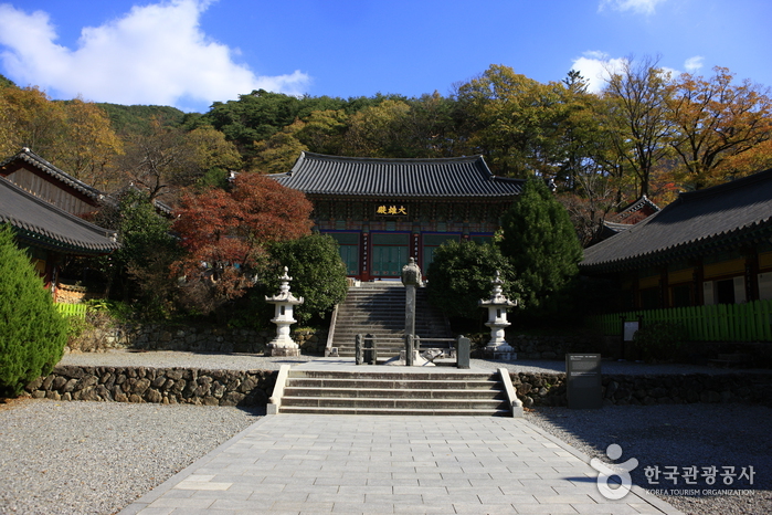
Hadong Ssanggyesa Temple (쌍계사(하동))
15.3Km 37157 2024-03-08
59 Ssanggyesa-gil, Hadong-gun, Gyeongsangnam-do
Ssanggyesa Temple was founded on the southern foothills of Jirisan Mountain in 722 during the reign of Silla King Seongdeok. The temple is famous for the 6-kilometer stretch of cherry blossom trees that bloom each spring. The temple was originally called Okcheonsa Temple, but was changed to the current Ssanggyesa Temple in 887. The current temple buildings were all built in 1632, after having been burned down during the Imjin War (1592-1598). The temple grounds and nearby area feature many historic and beautiful attractions, including Burilpokpo Falls and a large tea plantation.
Burilpokpo Falls (불일폭포)
15.5Km 46440 2024-02-08
103 Mogap-gil, Hwagae-myeon, Hadong-gun, Gyeongsangnam-do
Situated 720 meters above sea level, Burilpokpo Falls stands as the tallest waterfall on Jirisan Mountain, boasting a x_height of 60 meters and a x_width of 3 meters. It features a distinctive two-tier structure, with the enchanting Yongchumot and Hangmot Ponds nestled below, adding to its profound natural allure. Conveniently located just 3 kilometers from Ssanggyesa Temple, it's an ideal spot to visit following a trip to the temple.
Samseonggung (삼성궁)
15.5Km 56428 2024-02-21
86-15 Samseonggung-gil, Cheongam-myeon, Hadong-gun, Gyeongsangnam-do
Samseonggung is a Taoist shrine located at 850 meters above sea level on Jirisan Mountain. It serves as a spiritual hub for practicing Sinseondo, embodying traditional Korean culture. In 1983, Kang Min-ju (Taoist Priest Hanpul), along with his disciples, restored the sodo, a sacred altar from the Gojoseon period. This shrine stands as a revered sanctuary, honoring the primal ancestors of the Korean people: Hwanin (Lord of Heaven), Hwanung (Supreme Divine Regent), and Dangun (legendary founder of Gojoseon).
 English
 한국어
한국어 日本語
日本語 中文(简体)
 Deutsch
 Français
 Español
 Русский