15.9Km 2024-04-07
255 Jeongnyeongchi-ro, Jucheon-myeon, Namwon-si, Jeonbuk-do
+82-63-630-8900
Jirisan National Park is the second-highest mountain in South Korea, standing at an elevation of 1,915 meters, spanning across the provinces of Gyeongsang-do and Jeolla-do. Revered as a sacred mountain alongside North Korea's Baekdusan Mountain, it is home to the Asiatic Black Bear and features numerous peaks, including Cheonwangbong Peak. In spring, various flowers such as Royal Azalea bloom, while lush forests thrive in summer, vibrant foliage adorns the landscape in autumn, and the winter scenery boasts snow-covered peaks and icy landscapes.
16.1Km 2022-08-22
3145-1, Seomjingang-daero, Hadong-gun, Gyeongsangnam-do
+82-55-883-9004
Situated along Seomjingang River between Gurye and Hadong, Pyeongsari Park was built for the enjoyment of summer tourists to the area. In addition to the beautiful river, the park is home to campgrounds, numerous shaded rest spots, basketball courts, soccer fields, and an abundance of parking space. Decorated with Jangseung (totem poles, which used to be set at the entrance of villages), the spacious park is full of excellent amenities: barbecue grills, benches, drinking fountains, and clean bathrooms. The sandy banks of the river offer a unique opportunity to catch marsh clams.
Pyeongsari Park and its nearby attractions appeared in Toji (The Land), the epic historical novel by Park Kyung-ni. Visitors may want to tour the group of houses that have been reproduced to commemorate the novel, including the famous Choi Champan House.
Nearby attractions include Hwagae Market, Ssanggyesa Temple, and Seomjingang Maehwa Village, host of the Gwangyang Maehwa Festival.
16.9Km 2022-07-29
Chuseong-ri, Hamnyang-gun, Gyeongsangnam-do
+82-55-970-1000
Chilseongyegok Valley is the most beautiful valley in Jirisan Mountain, and is one of the top three valleys in the nation, along with Cheonbuldonggyegok Valley in Seoraksan Mountain and Tamnagyegok Valley in Hallasan Mountain. The 16-kilometer valley stretching from Uitan of Macheon-myeon to Cheonwangbong Peak is characterized by very tough topography but beautiful scenery and is the only remaining primeval forest of Jirisan Mountain. It is also dotted with seven waterfalls and 33 ponds. The hike becomes more difficult as the trail enters the valley. Because the valley has taken many lives, some people call it "The Valley of Death." For that reason, visitors must apply in advance and hike with a guide. The trail in Chilseon Valley is a 9.4-kilometer course from Chuseong Village in Macheon-myeon to Cheonwangbong Peak, which does not follow the natural valley, due to the valley's steep and dangerous features. Starting from Chuseong Village, the trail passes Yongso Pond, Jujiteo Site, Chuseongmang Rock, Seonnyeotang Pond, Ongnyeotang Pond, Biseondam, Chilseonpokpo Falls, Daeryukpokpo Falls, Samcheungpokpo Falls and Mapokpo Falls, all before reaching Cheonwangbong Peak.
17.4Km 2025-03-28
Bancheon-ro, Sicheon-myeon, Sancheong-gun, Gyeongsangnam-do
* Please be advised that this is located in one of the areas affected by the recent wildfire (as of March 27, 2025).
** For real-time wildfire information and emergency upates, visit the Korea Forestfire Information website and the National Disaster and Safety Portal.
Goundonggyegok Valley, nestled within Jirisan Mountain, is renowned for its extraordinary beauty. It also has historical significance as a resting place for the esteemed Confucian scholar Choe Chiwon during his journeys around the mountain. Characterized by crystal-clear waters and dense forests, the valley boasts a breathtaking landscape. In the summer, it becomes a sought-after destination for those seeking respite from the heat, while in autumn, its celebrated vibrant foliage draws numerous visitors.
18.0Km 2024-04-07
Guryongpokpo-gil, Namwon-si, Jeonbuk-do
+82-55-972-1000
Guryonggyegok Valley, a 3 kilometer-long valley in the northern part of the Jirisan National Park, located in Namwon, Jeollabuk-do, is just the place to enjoy a panoramic view of the unusually shaped rocks and precipitous cliffs. Under the Guryongpokpo Falls, located at the peak of the valley, is a small pond called, ‘Yongso’ (meaning ‘dragon pond’). Legend has it that a dragon lived here before it ascended to heaven. Visitors can tour the valley by driving along the skyway, an extension of the tourist road of Jirisan Mountain, or take an invigorating hike up a mountain by taking the Jeongnyeongchigan route, which extends along the valley to Baemsagol Valley(Banseon) and Nogodan Peak.
18.3Km 2024-02-21
27-79 Gwangjeom-gil, Macheon-myeon, Hamyang-gun, Gyeongsangnam-do
Seoamjeongsa Temple belongs to Byeoksongsa Temple, which is at the entrance of the Chilseongyegok Valley of Jirisan Mountain. Monk Woneung rebuilt Byeoksongsa Temple, which had been damaged during the Korean War in 1950. This hermitage features the Buddha statues Woneung carved into the natural bedrock, a grotto sanctuary with statues of the Pure Land, Daebanggwangmun Gate, and Sajagul Cave.
18.5Km 2024-12-24
43 , Daejeongbangcheon-gil, Namwon-si, Jeonbuk-do
+82-63-636-1003, +82-10-8107-1838
Jirisan Hanok Village, in Namwon-si, Jeollabuk-do, is a famous old house at the foot of Jirisan National Park’s Cheonwangbong and Nogodan Peaks. Just 20 minutes by car away from Nogodan and Baemsagol Valley Trail, the place is popular with walkers especially in the summer. Businessmen, poets and writers come here for the beautiful scenery; in particular, a candidate for the 2008 Nobel Prize in Literature stayed and worked here for a while.
18.5Km 2024-04-07
94-129, Ipseok-gil, Namwon-si, Jeonbuk-do
+82-63-636-3031
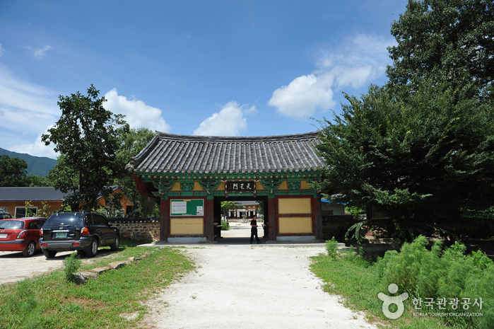
Silsangsa Temple was constructed by Monk Jeunggak, as one of nine special temples in the year 828. The temple was established because of the theory of divination, based on topology. The belief held that Korea’s good spirit would be taken away to Japan, bringing bad luck if the temple was not constructed at this particular location. The temple was reconstructed in the 26th year of King Sukjong’s reign (1700) after it was completely destroyed during the Imjin War (1592-1598). However, it was almost burnt down in the 19th year of King Gojong’s reign (1882).
It is presently preserved just as it was during the Unified Silla Kingdom, with its three-story pagoda and its 11 treasures with a total of 17 cultural assets. The entrance of the temple lies in the middle of a rice field and the temple has a pastoral view, surrounded by trees. From the entrance, visitors can cross the half-moon shaped stone bridge to find a remarkable totem pole.
18.7Km 2024-04-07
196, Baraebong-gil, Namwon-si, Jeonbuk-do
+82-63-630-8900
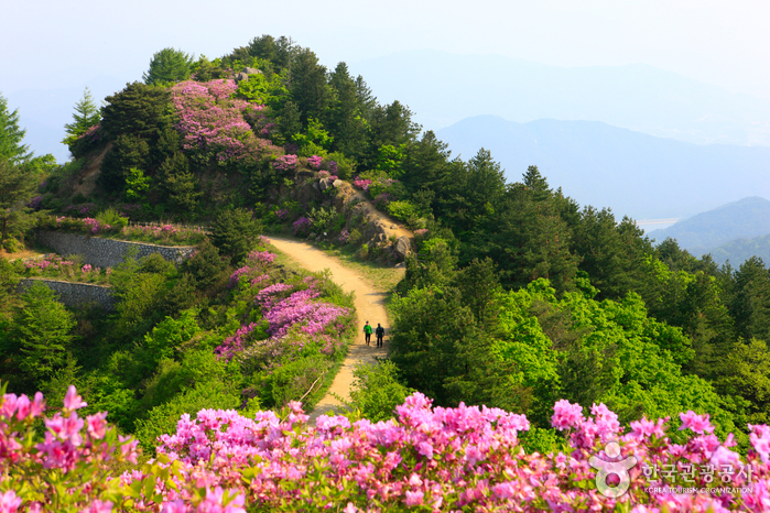
Baraebong Peak gets its name from its resemblance to an upside down barittae (a wooden rice bowl used by temple priests). The mountain is characterized by round slopes and fields of royal azalea flowers in spring. Trekking starts at Yongsan Village, 1.5 kilometers away from Unbong-eup. The trail follows a gentle path through a forest reserve behind a ranch and up to the peak. The last section of the trail before reaching the summit is covered in royal azaleas in full bloom from late April until May. The view from the peak includes the whole vista of Jirisan Mountain.
19.7Km 2024-02-22
1234 Seomjingang-ro, Gurye-eup, Gurye-gun, Jeollanam-do
Gokseong Seomjingang Astronomical Observatory is an astronomical observatory located along the Seomjingang River, equipped with a 600mm astronomical telescope and various other telescopes. It features a Main Observatory, Auxiliary Observatory, and an Planetarium for observing stars and the sun. Experience facilities include a 4D & VR Theater, VR Gyroscope, Space Elevator, and a Children's Experience Center.