![Jiktangpokpo Falls [National Geopark] (직탕폭포 (한탄강 국가지질공원))](http://tong.visitkorea.or.kr/cms/resource/70/1137370_image2_1.jpg)
Jiktangpokpo Falls [National Geopark] (직탕폭포 (한탄강 국가지질공원))
5.4Km 32349 2021-09-25
94, Jiktang-gil, Cheorwon-gun, Gangwon-do
+82-33-450-5534
Jiktangpokpo Falls is location in the middle of Hantangang River, which runs through town of Dongsong-eup in Cheorwon. Unlike other falls, Jiktangpokpo Falls is not tall, but wide instead as the 3 meter-high falls stretch almost 60 meters from bank to bank. Widely known for its grandeur and beauty, Jiktangpokpo Falls is one of the 8 scenic wonders of Cheorwon. It is an ideal summer vacation spot and visitors can enjoy the savory maeuntang (spicy seafood stew) made with freshwater fish at one of the many restaurants located in the vicinity.
![[Long-lasting Small Business] Cheorwon Makguksu ([백년가게]철원막국수)](http://tong.visitkorea.or.kr/cms/resource/19/2565319_image2_1.jpg)
[Long-lasting Small Business] Cheorwon Makguksu ([백년가게]철원막국수)
5.6Km 132 2024-03-20
13 Myeongseong-ro 158beon-gil, Galmal-eup, Cheorwon-gun, Gangwon-do
Cheorwon Makguksu boasts a 60-year tradition, offering a testament to its culinary expertise. The restaurant is known for pairing its makguksu with nokdu bindaetteok (mung bean pancake) and pyeonyuk (boiled pork slices), creating a harmonious trio that is often ordered together. Their mul makguksu features buckwheat noodles in a deep and cool broth, delivering a rich flavor without being overwhelming. The noodles are both chewy and tender, striking a perfect balance. Additionally, the dish is garnished with sweet-and-sour musaengchae (julienne radish fresh salad), adding a savory and clean note.
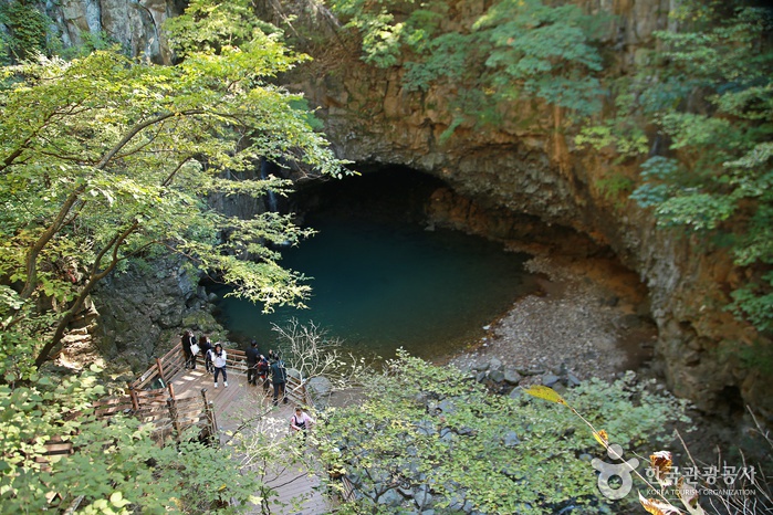
![Sambuyeonpokpo Falls [UNESCO Global Geopark] (삼부연폭포 (한탄강 유네스코 세계지질공원)](http://tong.visitkorea.or.kr/cms/resource/38/1750438_image2_1.jpg)
Sambuyeonpokpo Falls [UNESCO Global Geopark] (삼부연폭포 (한탄강 유네스코 세계지질공원)
5.7Km 22029 2024-03-20
Sincheorwon-ri, Galmal-eup, Cheorwon-gun, Gangwon-do
+82-33-450-4810
Sambuyeonpokpo Falls, among the nine scenic spots in Cheorwon, is a three-tiered waterfall standing at approximately 20 meters high, situated in the granite area of Myeongseongsan Mountain. This natural wonder was formed by water flowing over an extended period subsequent to the exposure of granite intrusion from the Mesozoic Cretaceous period, estimated to be around 110 million years ago. The name "Sambuyeon" originates from the distinctive three bends in the water stream and the lower part of the waterfall's resemblance to a cauldron.
Cheorwon Dopiansa Temple (도피안사(철원))
9.0Km 12718 2022-11-14
23, Dopidong-gil, Cheorwon-gun, Gangwon-do
+82-33-455-2471
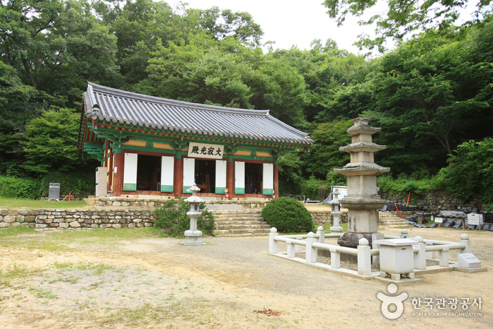
Dopiansa Temple was built by the Buddhist Monk Doseon in 865, the 5th year of the reign of King Gyeongmun of the Unified Silla Period. Legend has it that Monk Doseon founded this temple because a 91 centimeter-tall iron seated Vairocana Buddha statue had disappeared while being carried to Anyangsa Temple in Cheorwon and was mysteriously found seated at the current site.
The temple was named Dopiansa to indicate that the iron-made Buddha statue had reached “pian,” meaning an eternal place to rest. In addition to the legendary iron seated Variocana Buddha statue (National Treasure) made by Monk Doseon, the temple houses a 4.1 meter-tall three-story stone pagoda (Treasure).
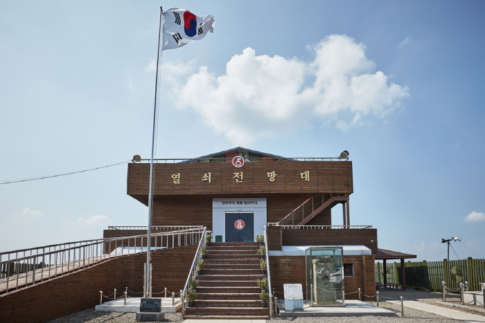
Key Observatory (열쇠전망대)
9.4Km 13020 2022-09-07
1375-1, Dongnae-ro, Yeoncheon-gun, Gyeonggi-do
+82-31-839-2147
Called to play the role of an important key for unification, Key Observatory was established on April 11, 1998 to commemorate the sorrow of homesickness and provide security education in the area. Military in the area can also keep watch over the north from this location. Visitors can see the DMZ fences and the Guard Point as well as exhibition hall where war items can be found.
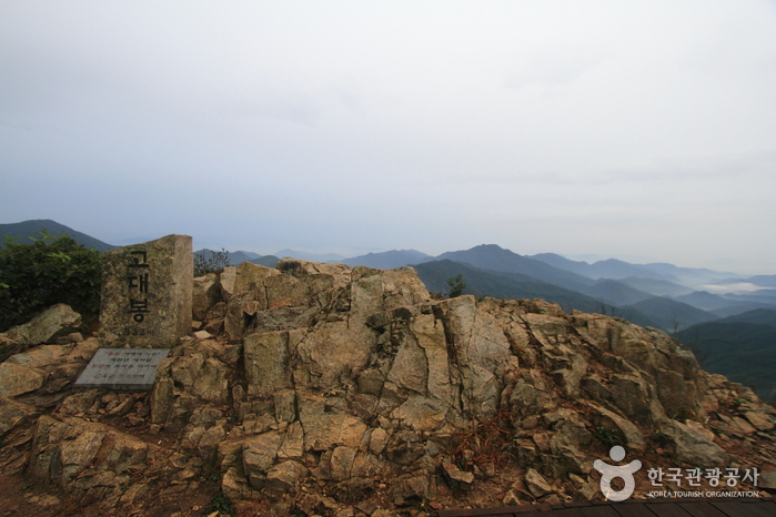
Godaesan Mountain (고대산)
9.5Km 54539 2021-07-20
Sinseo-myeon, Yeoncheon-gun, Gyeonggi-do
+82-31-839-2061
Godaesan Mountain (alt. 832 meters) is located next to Sintan-ri Station, which is the railroad disconnection point of the Gyeongwon Line. It is also on the way to Geumgangsan Mountain. Godaesan is ideal for mountain hiking because of its natural beauty and well-preserved
ecosystem. Moreover, this is the only mountain in South Korea on which the North Korean territory can be seen.
There are several theories about the origin of the mountain's name. One is that the mountain had been referred to as "keungore" (big whale) in the past by local residents. Another is that the mountain looks like the
banggorae (smoke duct) of a traditional Korean heating system when seen from the Sintan area; this is because the mountain's deep valleys resemble the furrows under that house that facilitate the passage of hot air to heat the room above. On a topographic map, the mountain was also marked as "Gotae" (like the constellations high above).
Godaesan also has a dense forest, making it a suitable source of timber and charcoal. Because of its abundant forest resources, a jumak (a tavern or inn that served food and liquor and provided lodging to travelers) village was formed here. The place was well-known for
charcoal production prior to the Korean War.
On November 4, 1907, 150 soldiers from the Korean militia fought a fierce battle with the 8th Company of the Japanese Army's 20th Infantry Regiment in Yeoncheon. After the fight, the Korean militia were scattered throughout the jumak village. Later on, 60 of them engaged in a
fierce battle again with the Japanese soldiers on Godaesan. This is a place imbued with the brave spirit of the Korean people.
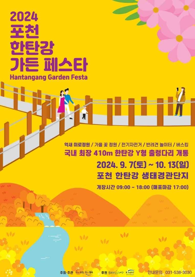
Hantangang Garden Festa (포천 한탄강 가든페스타)
9.6Km 0 2024-09-04
832 Changdong-ro, Gwanin-myeon, Pocheon-si, Gyeonggi-do
+82-31-538-3030
The Hantangang Garden Festa focuses on the healing aspect of nature, featuring a silver grass maze, autumn flower garden, electric bicycle rides, pet playground, and more. The silver grass maze in particular is a great way to enjoy all autumn has to offer, as well as take beautiful pictures. Family visitors love the bicycle rides.
Bidulginangpokpo Falls-Hantangang River Geopark (비둘기낭폭포-한탄강 국가지질공원)
9.7Km 303 2019-09-03
Daehoesan-ri, Pocheon-si, Gyeonggi-do
+82-31-538-2312
Bidulginangpokpo Falls, Natural Monument No. 537, is located within a small valley. The waterfall is surrounded by grand columnar joints. The landscape appears quite mysterious and serene, earning it a spot as a poplar filming site for historical dramas. The falls gets it's name ("Pigeon Falls" in Korean) from the story of many wild pigeons nesting in the caves around the waterfall. Other say the name comes from the area's shape. During heavy rainfall, the road to the waterfall is closed, so checking the weather before visiting is recommended.
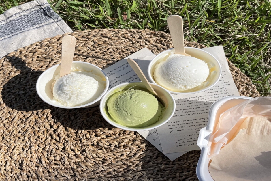
Saruru Farm (사르르목장)
10.6Km 0 2024-02-08
130 Sanjeonghosu-ro, Yeongbuk-myeon, Pocheon-si, Gyeonggi-do
Saruru Farm is a café known for its bright and neat atmosphere, with large windows providing views of rice fields and farms. The café's signature menu items include homemade soft ice cream made from Pocheon ranch's fresh milk and homemade kaymak. They also offer unique ice cream topped with Korean-style toppings like konggomul (roasted soybean powder).
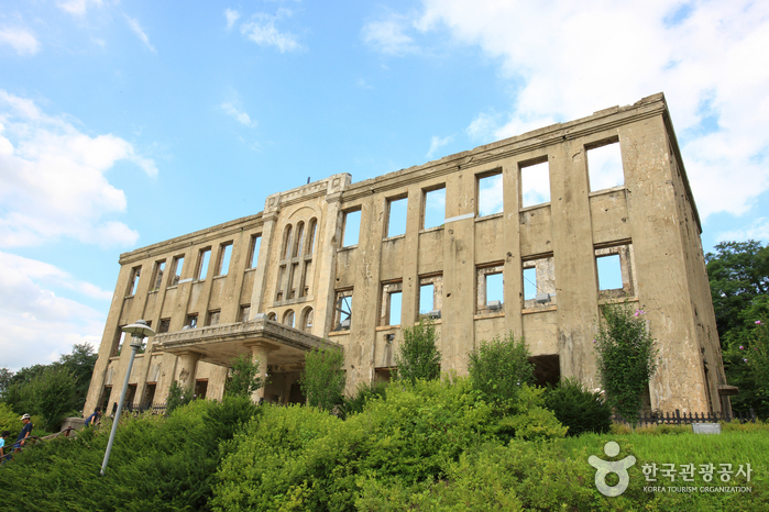
Cheorwon Korean Workers' Party Headquarters (철원 노동당사)
11.1Km 25738 2023-03-07
265, Geumgangsan-ro, Cheorwon-gun, Gangwon-do
+82-33-450-5558
This three-story building located in Cheorwon-eup was constructed in 1946. Used as the headquarters of the Labor Party until the break of the Korean War on June 25, it is now a tourist attraction that still holds onto the vestiges of the Korean War.
Cheorwon Korean Workers' Party Headquarters is under the control of Cheorwon-gun Office as part of the Security Tour Course. Hundreds of thousands of people visit this tourist destination every year.
 English
 한국어
한국어 日本語
日本語 中文(简体)
 Deutsch
 Français
 Español
 Русский