
Saemangeum Trail (새만금 광역탐방로)
13.9Km 2024-04-06
1192-1 Hwapo-ri, Jinbong-myeon, Gimje-si, Jeonbuk-do
Saemangeum Trail is a walking trail designed to showcase the exceptional natural scenery near the Mangyeonggang River. Spanning a total of 12.5 kilometers, starting from Mangyeong-eup's Tojeong Village and leading to Jinbong-myeon's Sampo Village, this trail allows walkers to immerse themselves in expansive rice paddy and lush greenery. Along the Mangyeonggang River, visitors can also observe various protected plant and animal species inhabiting the area.
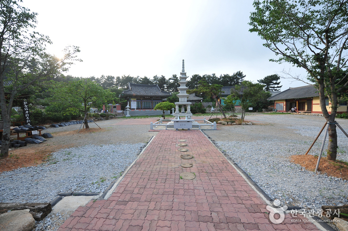
Gimje Seongmoam Hermitage (성모암(김제))
14.6Km 2024-04-07
54-9, Hwapo3-gil, Gimje-si, Jeonbuk-do
+82-63-544-0416
Seongmoam Hermitage, a temple of the Jogye Order, is located on Yuangsan Mountain in Mangyeong-myeon, Gimje-si. The temple is the final resting place of the mother of Jinmuk Daesa, a great Buddhist monk from the Jeonbuk region. Jinmuk believed that a person’s love and respect for Buddha is not that much different from the love and respect one has for his or her parents. As an expression of this philosophy, Jinmuk had his mother’s remains enshrined at the temple after she died at Mujasoncheonnyeonhyanghwajiji.
A neat little line of stone lamps leads visitors up from the parking lot to the temple grounds, revealing the well-attended grave of Jinmuk Daesa’s mother to the left. The temple is very unique in that it is the only one to house a caretaker’s office (Gosiraejoen Hall) that is responsible for maintaining the grave site.
It is said that prayers made to Seongmo (the holy mother) while visiting the temple will come true. Throughout the year, throngs of people journey to the temple to pay their respects and earnestly ask the holy mother to grant them their deepest desires.
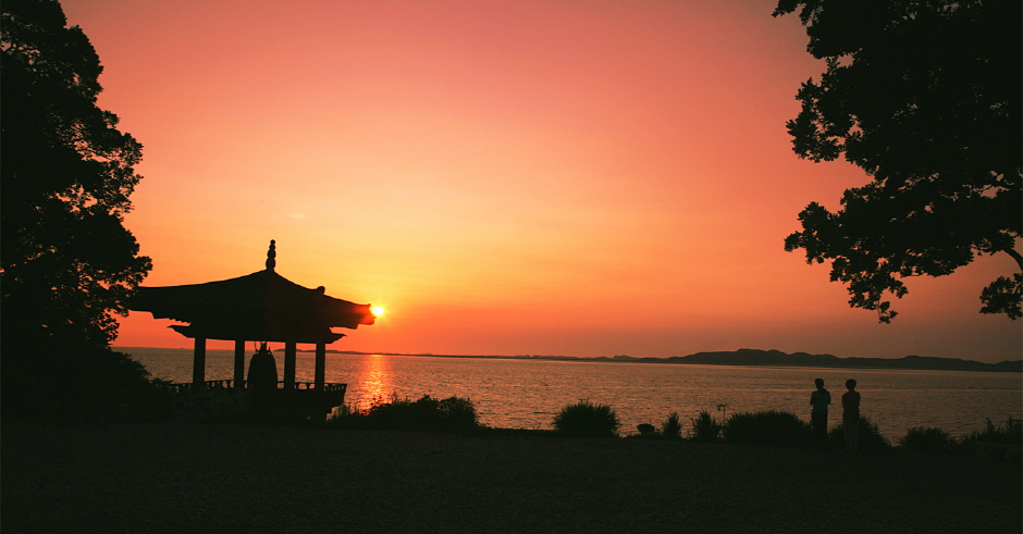
Manghaesa Temple (망해사)
15.9Km 2024-04-07
94, Simpo 10-gil, Gimje-si, Jeonbuk-do
+82-63-540-3324
Manghaesa Temple is located at the edge of the Gimje Plains before the sea. The temple stands at the summit of Jinbongsan Mountain. The temple was named for the view of the ocean and the fields of rice. The temple was established by the great monk Buseol Geosa during the 2nd year of King Uija of Baekje (AD 642). Years later, Dobeopsa (a Chinese monk from the Tang dynasty) renovated the temple. The temple was altered again during the reign of King Injo of the Joseon dynasty when the great monk Jinmuk Daesa built Nakseojeon Hall in 1589. Bogwangjeon Hall and Chilseonggak Pavilion were built much later in 1933. Manghaesa Temple is unique in that it is the only temple where the distant horizon is visible over both land and sea. Nearby attractions include a walking path through a field of reeds by Mangyeonggang River and views of the sunset over the sea.
Bieung Mapaji Trail (비응 마파지길)
18.0Km 2024-04-06
1331 Oehang-ro, Gunsan-si, Jeonbuk-do
Bieung Mapaji Trail is a deck walkway along the coast of Biungdo Island. "Mapaji" means a place where the maparam (south wind) blows in Korean, and visitors can enjoy a refreshing walk while feeling the cool breeze from the sea. While strolling along the coastal scenery, visitors come across observation decks. From these decks, they can enjoy panoramic views of Bieung Port and the expansive scenery of the Seohae Sea.
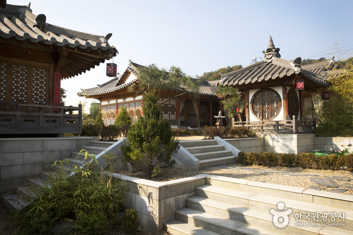
Seodongyo Theme Park (서동요 테마파크)
18.0Km 2025-10-23
616 Chungsin-ro, Buyeo-gun, Chungcheongnam-do
+82-41-832-9913
Seodongyo Theme Park is an open film set studio in a huge 33,000 square meter plot of land. The theme park offers various sets from Goryeo to Joseon dynasty as well as royal residences of Baekje dynasty, the commoners’ village, the village of the nobles and more. The set was the backdrop of various dramas including “Ballad of Seodong (2005), “The Great Sheer (2012)” and more. Visitors can also engage in various experience programs.
◎ Travel information to meet Hallyu’s charm - TV series "Moon Lovers: Scarlet Heart Ryeo"
Seodongyo Theme Park is a Baekje-themed set. The buildings that preserve the traditional architectural style and quaint scenery will make you feel like you’ve traveled back in time along with Hae-soo.
Bieung Port (비응항)
18.8Km 2024-04-07
74-11 , Bieungnam-ro, Gunsan-si, Jeonbuk-do
+82-63-454-4000
Bieung Port is the starting point of Saemangeum Embankment which is at the entrance of the Saemangeum tourist area. Bieung Port was once closed due to the excess of soil sedimentation after the construction of Geumgang Estuary seawall. In addition, when the shores were closed off with the Saemangeum Embankment reconstruction project, a new port was in need and thus Bieung Port was repaired and reopened along with two other ports. Bieung Port in particular was constructed as a multi-functioning fisheries port so that it may be incorporated with the nearby attractions in the tourism business.
Iksan Sungnimsa Temple (숭림사(익산))
18.9Km 2024-04-07
495-57, Baekje-ro, Iksan-si, Jeonbuk-do
+82-53-862-6394
Sungnimsa Temple is one of the major temples in Iksan under Geumsansa Temple and was believed by some to have been built by monk Jinpyo Yulsa during the reign of King Gyeongdeok (742-764) during the Silla period. Others believe that the temple was established during the first year of King Chungmok of the Goryeo dynasty in 1345. Sungnimsa Temple was named in honor of great monk Bodhi-Dharma, who practiced seated Zen meditation for nine years at Sorimsa Temple located deep inside Sungsan Mountain in China. The temple was burnt down during the Imjin War (1592-1598), leaving only Bogwangjeon Hall. Bits and pieces of the temple were later restored in 1697, 1819, and 1892.
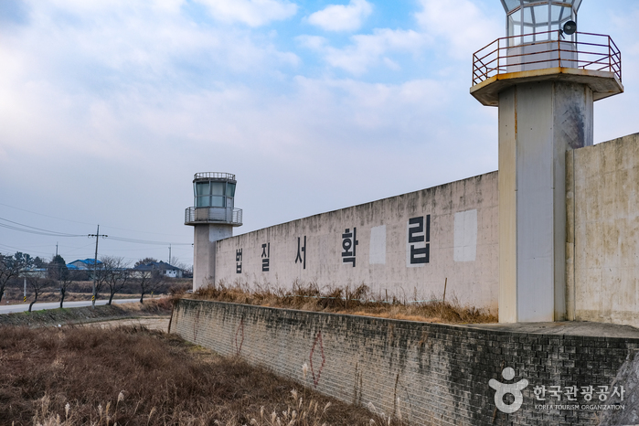
Iksan Prison Set (익산교도소세트장)
19.6Km 2025-10-24
207 Hamnang-ro, Seongdang-myeon, Iksan-si, Jeollabuk-do
It is the only prison set in Korea made for movie filming. Dramas like "Delightfully Deceitful" and " Divorce Attorney Shin" and movies like "Tazza" and "Miracle in Cell No. 7" were filmed here. Although the set was built using a closed school, shooting photos in places like the court, solitary confinement, interrogation rooms, and torture chambers can feel eerie. Renting costumes and becoming a correctional officer or inmate provides a more realistic prison experience.
 English
 한국어
한국어 日本語
日本語 中文(简体)
 Deutsch
 Français
 Español
 Русский